
| Divisions of Bihar | |
|---|---|
 | |
| Category | Administrative division |
| Location | Bihar |
| Number | 9 |
| Government | |
| Subdivisions |
|
Structurally Bihar is divided into divisions (Pramandal - प्रमंडल)), districts (Zila), sub-divisions (Anumandal) & circles (Anchal).[1][2] The state is divided into 9 divisions, 38 districts, 101 subdivisions and 534 circles.[3] 12 municipal corporations, 49 Nagar Parishads and 80 Nagar Panchayats for administrative purposes.[4][5][6][7][8]
YouTube Encyclopedic
-
1/5Views:91 6405 7971 647110 2644 866
-
Bihar Districts Name and their Divisions (बिहार के 9 प्रमंडल और 38 जिले) || Bihar Map
-
#BPSC#बिहार के प्रमंडल और जिले। Bihar Districts#Division of Bihar #Districts of Bihar#BPSC#STATE PCS
-
Bihar Polity | Day 09 | Overview of Politics and Administrative Division | 67th BPSC Prelims
-
Administrative divisions of India explained - Indian Polity for UPSC, State PSC, Judicial Exams
-
बिहार की प्रशासनिक व्यवस्था | Administration of Bihar | Administrative Division Of Bihar
Transcription
Divisions
| Map | Division | Headquarter | Area | Population*2011 | #District | Districts |
|---|---|---|---|---|---|---|
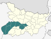
|
Patna | Patna | 16,960 km2
(6,550 sq mi) |
17,734,739 | 6 | Patna |
| Nalanda | ||||||
| Bhojpur | ||||||
| Rohtas | ||||||
| Buxar | ||||||
| Kaimur | ||||||

|
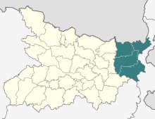
Tirhut | Muzaffarpur | 17,147 km2
(6,620 sq mi) |
21,356,045 | 6 | West Champaran |
| East Champaran | ||||||
| Muzaffarpur | ||||||
| Sitamarhi. | ||||||
| Sheohar | ||||||
| Vaishali | ||||||

|
Saran | Chhapra | 6,893 km2
(2,661 sq mi) |
10,819,311 | 3 | Saran |
| Siwan | ||||||
| Gopalganj | ||||||

|
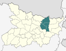
Darbhanga | Darbhanga | 8,684 km2
(3,353 sq mi) |
15,652,799 | 3 | Darbhanga |
| Madhubani[9][10] | ||||||
| Samastipur | ||||||
|
Kosi | Saharsa | 5,899 km2
(2,277 sq mi) |
6,120,117 | 3 | Saharsa |
| Madhepura | ||||||
| Supaul | ||||||
|
Purnea | Purnea | 10,009 km2
(3,864 sq mi) |
10,838,525 | 4 | Purnia |
| Katihar | ||||||
| Araria | ||||||
| Kishanganj | ||||||

|
Bhagalpur | Bhagalpur | 5,589 km2
(2,158 sq mi) |
5,061,565 | 2 | Bhagalpur |
| Banka | ||||||

|
Munger | Munger | 9,862 km2
(3,807 sq mi) |
6,120,117 | 6 | Munger |
| Jamui | ||||||
| Khagaria | ||||||
| Lakhisarai | ||||||
| Begusarai | ||||||
| Sheikhpura | ||||||

|
Magadh | Gaya | 12,345 km2
(4,766 sq mi) |
10,931,018 | 5 | Gaya |
| Nawada | ||||||
| Aurangabad | ||||||
| Jehanabad | ||||||
| Arwal |
Note :
* Population data obtained from the sum of the populations of the districts.[11]
Summary
| Division | Headquarters | Districts | District map of Bihar |
|---|---|---|---|
| Patna
|
Patna | Bhojpur, Buxar, Kaimur, Patna, Rohtas, Nalanda | 
|
| Saran | Chapra | Saran, Siwan , Gopalganj | |
| Tirhut | Muzaffarpur | East Champaran, Muzaffarpur, Sheohar, Sitamarhi, Vaishali, West Champaran | |
| Purnia | Purnia | Araria, Katihar, Kishanganj, Purnia | |
| Bhagalpur | Bhagalpur | Banka, Bhagalpur | |
| Darbhanga | Darbhanga | Darbhanga, Madhubani, Samastipura | |
| Kosi | Saharsa | Madhepura, Saharsa, Supaul | |
| Magadh | Gaya | Arwal, Aurangabad, Gaya, Jehanabad, Nawada | |
| Munger | Munger | Begusarai,Jamui, Khagaria, Munger, Lakhisarai, Sheikhpura |
See also
| Divisions | 9 |
|---|---|
| Districts | 38 |
| Subdivisions | 101 |
| Cities and towns | 207 |
| Blocks | 534 |
| Villages | 45,103 |
| Panchayats | 8,406 |
| Police Districts | 43 |
| Police Stations | 853 |
- India
- Bihar
- Government of Bihar
- Administration in Bihar
- Cities in Bihar
- Districts of Bihar
- Divisions of India
- Subdivisions of Bihar
- Blocks in Bihar
- Villages in Bihar
References
- ^ District Handbook of Bihar
- ^ Districts List by Govt. Of Bihar
- ^ "Indexing Gender Parity and Estimation of Child Marriage: A comprehensive study of 534 Blocks in Bihar". Archived from the original on 25 September 2017.
- ^ "Bihar Civic elections likely in May 2017". Archived from the original on 31 March 2017.
- ^ "बिहार : नगर विकास एवं आवास विभाग की पहल, पुनर्गठन से नगर परिषदों की बढ़ जायेगी संख्या". Archived from the original on 24 March 2017.
- ^ "पहली बार कोई महिला बनेगी पटना नगर निगम की मेयर". Archived from the original on 24 March 2017.
- ^ "Ward delimitation begins in Chhapra". Archived from the original on 27 February 2017.
- ^ "छपरा को निगम बख्तियारपुर को मिला नगर परिषद का दर्जा". Archived from the original on 24 March 2017.
- ^ "Official Website :: Home Page". darbhangadivision.bih.nic.in. Retrieved 24 January 2020.
- ^ "Official Website :: Home Page". 6 March 2019. Archived from the original on 6 March 2019. Retrieved 24 January 2020.
- ^ "District Census 2011". Census 2011. Archived from the original on 11 June 2011. Retrieved 26 December 2012.
This article related to a location in Bihar is a stub. You can help Wikipedia by expanding it. |