
 An aerial view of Alegranza | |
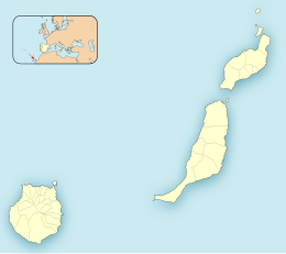 Alegranza Location in the province of Las Palmas  Alegranza Alegranza (Canary Islands)  Alegranza Alegranza (Spain, Canary Islands) | |
| Geography | |
|---|---|
| Coordinates | 29°23′56″N 13°30′43″W / 29.399°N 13.512°W |
| Archipelago | Chinijo Archipelago |
| Area | 10.202 km2 (3.939 sq mi) |
| Highest elevation | 289 m (948 ft) |
| Administration | |
| Autonomous Community | Canary Islands |
| Province | Las Palmas |
| Municipality | Teguise |
| Demographics | |
| Population | 0 (2013) |
Alegranza (Spanish pronunciation: [aleˈɣɾanθa]) is an uninhabited island in the Atlantic Ocean, located off the coast of Africa and is in the province of Las Palmas in the Canary Islands, Spain. It is the northernmost point in the Canary Islands, and part of the Chinijo Archipelago. The island is part of the municipality of Teguise on Lanzarote.
YouTube Encyclopedic
-
1/3Views:16 465441938
-
Alegranza
-
Alegranza 201 Los Cabos, Baja California Sur
-
Alegranza, Montaña Clara & La Graciosa
Transcription
Geographical overview
The area is 10.2 km². The island features a volcano with a crater of about 1.1 km in diameter and an altitude of 289 m. The second highest is Montaña de Lobos at 256 m and following La Rapagura. The northern portion is mainly flat.
-

NASA satellite image of Alegranza
-


Conservation
The island is part of the Chinijo Archipelago Natural Park (Parque Natural del Archipiélago Chinijo).[1][2] There are no inhabitants on the island.
The Punta Delgada Lighthouse is located in the eastern part of Alegranza. The lighthouse was built between 1861 and 1865 and was designated a historic monument (Bien de Interés Cultural) in 2002.[3]
History
Its name, derived from the Spanish word for "joy," was given, according to some scholars, by Jean de Bethencourt because he felt joy upon spotting land.[4] The island has been owned by the Jordán-Martinón family since the 1940s.[5]
See also
References
- ^ "Protected Natural Areas". Archived from the original on 17 April 2015. Retrieved 24 April 2014.
- ^ Boletín Oficial de Canarias, pages 9723 and 9865-7
- ^ Boletín Oficial del Estado
- ^ Municipios De Lanzarote (Teguise)
- ^ "Los dueños de Alegranza proponen gestionar el uso público del islote la zona". ABC (in Spanish). 15 March 2010. Retrieved 19 March 2012.
External links
 Media related to Alegranza at Wikimedia Commons
Islands and provinces of the Canary Islands | ||
|---|---|---|
| Main islands |  | |
| Other islands | ||
| Provinces | ||