

The Argentina–Chile border is the longest international border of South America and the third longest in the world after the Canada–United States border and the Kazakhstan–Russia border. With a length of 5,308 kilometres (3,298 mi),[1] it separates Argentina from Chile along the Andes and on the islands of Tierra del Fuego. However, there are some border disputes, particularly around the Southern Patagonian Ice Field. It is the largest border of the two countries, beating the Argentina–Paraguay and Chile–Bolivia, Argentina's and Chile's second largest borders, respectively.
YouTube Encyclopedic
-
1/2Views:4042 035
-
1922 Chile-Argentina Border Earthquake, stop motion
-
Argentina and Chile Border . #shorts #viral #explore #america #new #world #trending #trend #love
Transcription
Plot

The northern end of the border is a tripoint it forms with those at the Argentina–Bolivia border and the Bolivia-Chile border in the arid Puna de Atacama plateau. The border extends south until reaching the sea at the same place the Strait of Magellan meets the Atlantic Ocean. Further south the border on the Isla Grande de Tierra del Fuego follows a meridian separating the island into two. This boundary reaches the sea at Beagle Channel a few kilometers southwest of Ushuaia.
In November 1984 the southern border area was finally established after long negotiations and mediation of John Paul II by the Treaty of Peace and Friendship of 1984 between Chile and Argentina, a perpetual treaty, signed at the Vatican by representatives of both countries.
On 16 December 1998, an agreement between Argentina and Chile was signed to redefine the border line from Mount Fitz Roy and Mount Daudet and finish with the historical dispute. However both countries didn't agree in the section between Mount Fitz Roy and Mount Murallón, and the border is still pending to be defined.

The territorial claims of Argentina and Chile over Antarctica partially overlap with each other. Chile claims for itself the Chilean Antarctic Territory, which is included in the Region of Magallanes and Chilean Antarctica, while Argentina claims Argentine Antarctica, whose territory is part of the Province of Tierra del Fuego, Antarctica and South Atlantic Islands.
Both countries recognize each other's territories that do not overlap with their own as stipulated in the protocols of 1947, 1948, 1964, 1971 and 1978.[2]
-

-
 Marker (hito XXIV) in Tierra del Fuego.
 -
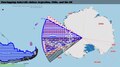 The overlapping claims to Antarctica of Argentina and Chile: Argentine Antarctica and the Chilean Antarctic Territory, both overlapping the UK's British Antarctic Territory.


See also
- Beagle Conflict, a border dispute between Chile and Argentina over the possession of Picton, Lennox, and Nueva islands and the scope of the maritime jurisdiction associated with those islands that brought the countries to the brink of war in 1978.
- Boundary Treaty of 1881, a treaty signed on July 23, 1881, by Bernardo de Irigoyen and Francisco de Borja Echeverría, which sought to clarify the existing Chile-Argentina border and establish a definite border between the two countries.
- Patagonia
- Argentine Chileans
- Chilean Argentines
- Mapuche
- Culture of Argentina
- Culture of Chile
- Argentina national football team
- Chile national football team
- Anti-Chilean sentiment
References
- ^ "Instituto Nacional de Estadística y Censos".
- ^ Pablo Rodríguez Márquez (2007). Chile y sus intereses en la Antártica: opciones políticas y de seguridad frente a la escasez de recursos hídricos (PDF). cademia Nacional de Estudios Políticos y Estratégicos.
External links
- (in Spanish) " Y Cronología REFERENCIAS GENERAL SOBRE LOS Acuerdos Y Tratados bordering SUSCRITOS POR ARGENTINA Y CHILE (1820-1998) '" on the site soberaniachile.cl '
- (in French) The Argentine-Chilean border '" on the site' 'persee.fr'
This article about a location in Argentina is a stub. You can help Wikipedia by expanding it. |
This Chile location article is a stub. You can help Wikipedia by expanding it. |