
Cannon Township, Minnesota | |
|---|---|
 Cannon Township Location in Minnesota and the United States  Cannon Township Cannon Township (the United States) | |
| Coordinates: 48°49′31″N 96°36′27″W / 48.82528°N 96.60750°W | |
| Country | United States |
| State | Minnesota |
| County | Kittson |
| Area | |
| • Total | 35.7 sq mi (92.6 km2) |
| • Land | 35.7 sq mi (92.6 km2) |
| • Water | 0.0 sq mi (0.0 km2) |
| Elevation | 997 ft (304 m) |
| Population (2000) | |
| • Total | 22 |
| • Density | 0.6/sq mi (0.2/km2) |
| Time zone | UTC-6 (Central (CST)) |
| • Summer (DST) | UTC-5 (CDT) |
| FIPS code | 27-09676[1] |
| GNIS feature ID | 0663741[2] |
Cannon Township is a township in Kittson County, Minnesota, United States. The population was 22 at the 2000 census.
Cannon Township was organized in 1904, and named for Thomas Cannon, a county official.[3]
Geography
According to the United States Census Bureau, the township has a total area of 35.7 square miles (92 km2), all land.
Demographics
As of the census[1] of 2000, there were 22 people, 8 households, and 7 families residing in the township. The population density was 0.6 inhabitants per square mile (0.23/km2). There were 21 housing units at an average density of 0.6 per square mile (0.23/km2). The racial makeup of the township was 95.45% White, and 4.55% from two or more races.
There were 8 households, out of which 37.5% had children under the age of 18 living with them, 75.0% were married couples living together, 12.5% had a female householder with no husband present, and 12.5% were non-families. 12.5% of all households were made up of individuals, and none had someone living alone who was 65 years of age or older. The average household size was 2.75 and the average family size was 3.00.
In the township the population was spread out, with 31.8% under the age of 18, 31.8% from 25 to 44, 9.1% from 45 to 64, and 27.3% who were 65 years of age or older. The median age was 34 years. For every 100 females, there were 120.0 males. For every 100 females age 18 and over, there were 114.3 males.
The median income for a household in the township was $36,250, and the median income for a family was $42,500. Males had a median income of $15,000 versus $18,750 for females. The per capita income for the township was $15,140. There are 16.7% of families living below the poverty line and 13.3% of the population, including no under eighteens and 33.3% of those over 64.
See also
References
- ^ a b "U.S. Census website". United States Census Bureau. Retrieved January 31, 2008.
- ^ "US Board on Geographic Names". United States Geological Survey. October 25, 2007. Retrieved January 31, 2008.
- ^ Upham, Warren (1920). Minnesota Geographic Names: Their Origin and Historic Significance. Minnesota Historical Society. p. 277.
Municipalities and communities of Kittson County, Minnesota, United States | ||
|---|---|---|
| Cities | 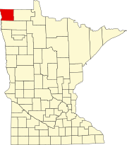 | |
| Townships | ||
| Unorganized territories | ||
| Unincorporated communities | ||
| Ghost town | ||