


Catalunyan Saddle (Katalunska Sedlovina \ka-ta-'lun-ska se-dlo-vi-'na\) is a saddle of 1260 m height in the Friesland Ridge of the Tangra Mountains on Livingston Island, in the South Shetland Islands. The saddle is bounded by Lyaskovets Peak to the east and by Presian Ridge to the west. The saddle was named in honour of the Catalans Francesc Sàbat (q.v. Sàbat Hill) and Jorge Enrique (q.v. Enrique Hill) from Juan Carlos I Base who established the first route via the saddle to Mount Friesland on 30 December 1991.
Location
The saddle is located at 62°39′58.5″S 60°08′51.2″W / 62.666250°S 60.147556°W which is 11.5 km east of St. Kliment Ohridski Base and 3.4 km south of Kuzman Knoll. Part of the saddle is occupied by an amazingly shaped ice-covered feature called the Sphinx.
The saddle was occupied by a bivouac of the Bulgarian Tangra 2004/05 Survey team (Lyubomir Ivanov and Doychin Vasilev) during 14 December–16 December 2004 and was mapped in 2005.
Maps
- L.L. Ivanov et al. Antarctica: Livingston Island and Greenwich Island, South Shetland Islands. Scale 1:100000 topographic map. Sofia: Antarctic Place-names Commission of Bulgaria, 2005.
- L.L. Ivanov. Antarctica: Livingston Island and Greenwich, Robert, Snow and Smith Islands. Scale 1:120000 topographic map. Troyan: Manfred Wörner Foundation, 2009. ISBN 978-954-92032-6-4
- L.L. Ivanov. Antarctica: Livingston Island and Smith Island. Scale 1:100000 topographic map. Manfred Wörner Foundation, 2017. ISBN 978-619-90008-3-0
- A. Kamburov and L. Ivanov. Bowles Ridge and Central Tangra Mountains: Livingston Island, Antarctica. Scale 1:25000 map. Sofia: Manfred Wörner Foundation, 2023. ISBN 978-619-90008-6-1
Gallery
-
 Catalunyan Saddle in the foreground, with Bransfield Strait in the foreground and the Antarctic Peninsula on the horizon
 -
 The Tangra 2004/05 Bivouac at Catalunyan Saddle
 -
 ‘The Sphinx,’ with Lyaskovets Peak on the left and Levski Peak on the right background
 -
 Catalunyan Saddle with 'The Sphinx' from Presian Ridge, with St. Ivan Rilski Col emerging from the fog in the background
 -
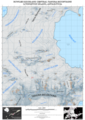 Topographic map of Bowles Ridge and central Tangra Mountains

References
- Catalunyan Saddle. SCAR Composite Antarctic Gazetteer
- Bulgarian Antarctic Gazetteer. Antarctic Place-names Commission. (details in Bulgarian, basic data in English)
- D. Gildea. Mountaineering in Antarctica: complete guide: Travel guide. Primento and Editions Nevicata, 2015. ISBN 978-2-51103-136-0
- Antarctica: Livingston Island, Climb Magazine, Issue 14, Kettering, UK, April 2006, pp. 89-91.
External links
- Catalunyan Saddle. Copernix satellite image
This article includes information from the Antarctic Place-names Commission of Bulgaria which is used with permission.