
Desamparados | |
|---|---|
 Flag  Seal | |
 Desamparados canton | |
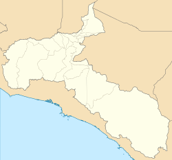 Desamparados Desamparados canton location in San José Province  Desamparados Desamparados canton location in Costa Rica | |
| Coordinates: 9°48′41″N 84°01′44″W / 9.8114083°N 84.0289552°W | |
| Country | |
| Province | San José |
| Creation | 4 November 1862[1] |
| City | Desamparados |
| Districts | |
| Government | |
| • Type | Municipality |
| • Body | Municipalidad de Desamparados |
| • Mayor | Gilbert Jiménez Siles (PLN) |
| Area | |
| • Total | 118.26 km2 (45.66 sq mi) |
| Elevation | 1,270 m (4,170 ft) |
| Population (2011) | |
| • Total | 208,411 |
| • Density | 1,800/km2 (4,600/sq mi) |
| Time zone | UTC−06:00 |
| Canton code | 103 |
| Website | www |
Desamparados is the 3rd canton in the province of San José in Costa Rica. The canton covers an area of 118.26 km2,[2] and has a population of 206,708,[3] making it the third most populated among the 81 cantons of Costa Rica. The canton's capital city is also called Desamparados.
The canton begins in the southern suburbs of the national capital city of San José, with the Río Tiribí marking its northern boundary. It snakes its way south as a backward ´S´, finally reaching its southern limit at the Río Tarrazú. It contains the bigger of the last forest lungs in the metropolitan area of the Costa Rican capital, the Loma Salitral, which conservation issues have generated social conflicts between community environmentalists and immobility developers, as it is seen as an identity mark of the desamparadeño people and a vital infiltration area to prevent the frequents and disastrous floods in the district of Gravilias.[4]
Urban areas claim 80.4% of the canton's population. Those under age 10 comprise 19.8% of its inhabitants, while 5.1% are over 65.
YouTube Encyclopedic
-
1/1Views:843
-
VIDA MUNICIPAL- Programa 13- Cantón de Desamparados
Transcription
Districts
The canton of Desamparados is subdivided into 13 districts (distritos):[5]
- Desamparados
- San Miguel
- San Juan de Dios
- San Rafael Arriba
- San Antonio
- Frailes
- Patarrá
- San Cristóbal
- Rosario
- Damas
- San Rafael Abajo
- Gravilias
- Los Guido
History
The canton was established by a legislative decree of November 4, 1862.
Sports
The football soccer club Orión F.C. de Desamparados plays here.
Demographics
| Historical population | |||
|---|---|---|---|
| Census | Pop. | %± | |
| 1864 | 7,067 | — | |
| 1883 | 5,408 | −23.5% | |
| 1892 | 6,471 | 19.7% | |
| 1927 | 9,463 | 46.2% | |
| 1950 | 15,614 | 65.0% | |
| 1963 | 33,845 | 116.8% | |
| 1973 | 74,272 | 119.4% | |
| 1984 | 108,824 | 46.5% | |
| 2000 | 193,478 | 77.8% | |
| 2011 | 208,411 | 7.7% | |
|
Instituto Nacional de Estadística y Censos[6] |
|||
For the 2011 census, Desamparados had a population of 208,411 inhabitants.[8]
Transportation
Road transportation
The following road routes cover the canton:
Notable people
- Máximo Fernández Alvarado
- Joaquín Garcia Monge
- Joel Campbell
- Roy Miller
- Laura Chinchilla
- Jorge Alejandro Castro
References

- ^ Hernández, Hermógenes (1985). Costa Rica: evolución territorial y principales censos de población 1502 - 1984 (in Spanish) (1 ed.). San José: Editorial Universidad Estatal a Distancia. pp. 164–173. ISBN 9977-64-243-5. Retrieved 5 October 2020.
- ^ Instituto Geográfico Nacional (IGN), 2001.
- ^ Estimates of Instituto Nacional de Estadística y Censos (INEC), May 2003.
- ^ "Sala IV resuelve a favor de la protección de la Loma Salitral en Desamparados".
- ^ "División Territorial Administrativa de Costa Rica" (PDF) (in Spanish). Instituto de Fomento y Asesoria Municipal (IFAM). 5 May 2009. Archived from the original (PDF) on 2015-08-02.
- ^ "Instituto Nacional de Estadística y Censos" (in Spanish).
- ^ "Sistema de Consulta de a Bases de Datos Estadísticas". Centro Centroamericano de Población (in Spanish).
- ^ "Censo. 2011. Población total por zona y sexo, según provincia, cantón y distrito". Instituto Nacional de Estadística y Censos (in Spanish). Retrieved 26 September 2020.
| International | |
|---|---|
| National | |
This Costa Rican location article is a stub. You can help Wikipedia by expanding it. |