
| Faridkot State | |||||||||
|---|---|---|---|---|---|---|---|---|---|
| Princely State of British India | |||||||||
| 1803–1947 | |||||||||
 Flag | |||||||||
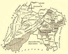 Faridkot State in a 1911 map of Punjab | |||||||||
| Capital | Faridkot | ||||||||
| Area | |||||||||
• 1892 | 1,652 km2 (638 sq mi) | ||||||||
| Population | |||||||||
• 1892 | 97,034 | ||||||||
| Historical era | New Imperialism | ||||||||
• Established | 1803 | ||||||||
| 1947 | |||||||||
| |||||||||
Faridkot State was a self-governing princely state of Punjab outside British India during the British Raj period in the Indian sub-continent until Indian independence.
History
Origin
It was founded by Sidhu-Brar Jats.[1]
Colonial period
Faridkot was one of the Cis-Sutlej states, which came under British influence in 1809. It was bounded on the west and northeast by the British district of Ferozepore, and on the south by Nabha State. During the First Anglo-Sikh War in 1845 the chief, Raja Pahar Singh, was allied with the British, and was rewarded with an increase of territory. In the Indian Rebellion of 1857, too, his son and successor, Wazir Singh, guarded the Sutlej ferries, and destroyed a rebel stronghold.[2]
Demographics
| Religious group |
1901[3] | 1911[4][5] | 1921[6] | 1931[7] | 1941[8] | |||||
|---|---|---|---|---|---|---|---|---|---|---|
| Pop. | % | Pop. | % | Pop. | % | Pop. | % | Pop. | % | |
| Sikhism |
52,721 | 42.21% | 55,397 | 42.52% | 66,658 | 44.24% | 92,880 | 56.51% | 115,070 | 57.74% |
| Islam |
35,996 | 28.82% | 37,105 | 28.48% | 44,813 | 29.74% | 49,912 | 30.37% | 61,352 | 30.79% |
| Hinduism |
35,778 | 28.64% | 37,377 | 28.69% | 38,610 | 25.63% | 20,855 | 12.69% | 21,814 | 10.95% |
| Jainism |
406 | 0.33% | 409 | 0.31% | 473 | 0.31% | 550 | 0.33% | 800 | 0.4% |
| Christianity |
11 | 0.01% | 6 | 0% | 107 | 0.07% | 167 | 0.1% | 247 | 0.12% |
| Zoroastrianism |
0 | 0% | 0 | 0% | 0 | 0% | 0 | 0% | 0 | 0% |
| Buddhism |
0 | 0% | 0 | 0% | 0 | 0% | 0 | 0% | 0 | 0% |
| Judaism |
0 | 0% | 0 | 0% | 0 | 0% | 0 | 0% | 0 | 0% |
| Others | 0 | 0% | 0 | 0% | 0 | 0% | 0 | 0% | 0 | 0% |
| Total population | 124,912 | 100% | 130,294 | 100% | 150,661 | 100% | 164,364 | 100% | 199,283 | 100% |
| Note: British Punjab province era district borders are not an exact match in the present-day due to various bifurcations to district borders — which since created new districts — throughout the historic Punjab Province region during the post-independence era that have taken into account population increases. | ||||||||||
See also
Notes
- ^ 1931-1941: Including Ad-Dharmis
References
- ^ Arora, A. C. (1982). British Policy Towards the Punjab States, 1858-1905. Export India Publications.
- ^ One or more of the preceding sentences incorporates text from a publication now in the public domain: Chisholm, Hugh, ed. (1911). "Faridkot". Encyclopædia Britannica. Vol. 10 (11th ed.). Cambridge University Press. p. 178.
- ^ "Census of India 1901. [Vol. 17A]. Imperial tables, I-VIII, X-XV, XVII and XVIII for the Punjab, with the native states under the political control of the Punjab Government, and for the North-west Frontier Province". 1901. p. 34. JSTOR saoa.crl.25363739. Retrieved 30 March 2024.
- ^ "Census of India 1911. Vol. 14, Punjab. Pt. 2, Tables". 1911. p. 27. JSTOR saoa.crl.25393788. Retrieved 30 March 2024.
- ^ Kaul, Harikishan (1911). "Census Of India 1911 Punjab Vol XIV Part II". p. 27. Retrieved 30 March 2024.
- ^ "Census of India 1921. Vol. 15, Punjab and Delhi. Pt. 2, Tables". 1921. p. 29. JSTOR saoa.crl.25430165. Retrieved 30 March 2024.
- ^ "Census of India 1931. Vol. 17, Punjab. Pt. 2, Tables". 1931. p. 277. JSTOR saoa.crl.25793242. Retrieved 30 March 2024.
- ^ "Census of India, 1941. Vol. 6, Punjab". 1941. p. 42. JSTOR saoa.crl.28215541. Retrieved 30 March 2024.
| International | |
|---|---|
| National | |
31°07′N 77°38′E / 31.117°N 77.633°E