


Fiddle Bow is an unincorporated community located in southwest Hopkins County, Kentucky, United States.[2] It was populated as early as 1913.[3] The town takes its name from a black oak tree that once lived in the area that had the appearance of a violin bow. A notorious highwayman, Micajah Harpe (AKA Big Harp), one of the Harpe brothers, was reputedly executed in the area.[4]
YouTube Encyclopedic
-
1/3Views:5 3821 2522 749
-
Uncle Pen played on the fiddle. Link to lesson!
-
University of Kentucky String Project Info
-
Bowing: The Sweet Spot
Transcription
Mining and resource-extraction activity
Fiddle Bow was home to an underground coal mine owned by the Pittsburgh and Midway Coal Company. As of 1980 it had a production capacity of 250,000 tons a year.[5] A strip mine was also located at Fiddle Bow with a production tonnage of 11,767 tons in 1980.[6]
In 1986 water from an old mine created what locals dubbed the "Fiddle Bow Geyser", with water spraying more than 50 feet in the air from a vent pipe.[7]
Oil was discovered at Fiddle Bow in 1968.[8]
References
- ^ U.S. Geological Survey Geographic Names Information System: Fiddle Bow, Kentucky
- ^ Field, Thomas Parry (1961). A Guide to Kentucky Place Names. College of Arts and Sciences, University of Kentucky. p. 91. Retrieved December 5, 2020.
- ^ "Fiddle Bow Items". The Hustler. September 23, 1913. p. 9. Retrieved December 5, 2020.
- ^ "Kentucky's Fiddle Bow District". The Kingston Daily Freeman. December 30, 1938. p. 14. Retrieved December 5, 2020.
- ^ Technical Bulletin, Issue 1627. U.S. Department of Agriculture. 1980. p. 150. Retrieved December 5, 2020.
- ^ U. S. Coal Mine Production by Seam. McGraw-Hill. 1980. p. 179. Retrieved December 5, 2020.
- ^ "Water from old coal mine creates 'Fiddle Bow Geyser' in Hopkins". The Courier-Journal. AP. February 22, 1986. p. 7. Retrieved December 5, 2020.
- ^ Oil and Gas Field Code Master List -- 1982. Energy Information Administration, Office of Oil and Gas. 1982. p. 128. Retrieved December 5, 2020.
Municipalities and communities of Hopkins County, Kentucky, United States | ||
|---|---|---|
| Cities | 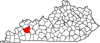 | |
| CDP | ||
| Other unincorporated communities |
| |
| Footnotes | ‡This populated place also has portions in an adjacent county or counties | |
This Hopkins County, Kentucky state location article is a stub. You can help Wikipedia by expanding it. |