

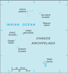
The British Indian Ocean Territory (BIOT) is an archipelago of 55 islands in the Indian Ocean, located south of India. It is situated approximately halfway between Africa and Indonesia. The islands form a semicircular group with an open sea towards the east. The largest, Diego Garcia, is located at the southern extreme end. It measures 60 square kilometres (23 sq mi) and accounts for almost three-quarters of the total land area of the territory.[1][disputed ] Diego Garcia is the only inhabited island and is home to the joint UK-US naval support facility.[2][3] Other islands within the archipelago include Danger Island, Three Brothers Islands, Nelson Island, and Peros Banhos, as well as the island groups of the Egmont Islands, Eagle Islands, and the Salomon Islands.[3]
YouTube Encyclopedic
-
1/5Views:11 371 892608 5067 8176 285 43618 668
-
The Difference between the United Kingdom, Great Britain and England Explained
-
French Overseas Regions and Territories Explained
-
Australian Empire: Overseas Territories Explained
-
American Empire
-
A History of the British Empire: Economy, Population, Military and Culture (2003)
Transcription
Welcome to the United Kingdom (and a whole lot more) explained by me, C. G. P. Grey The United Kingdom, England, Great Britain? Are these three the same place? Are they different places? Do British people secretly laugh those who use the terms wrongly? Who knows the answers to these questions? I do and I'm going to tell you right now. For the lost: this is the world, this is the European continent and this is the place we have to untangle. The area shown in purple is the United Kingdom. Part of the confusion is that the United Kingdom is not a single country but is instead a country of countries. It contains inside of it four co-equal and sovereign nations The first of these is England — shown here in red. England is often confused with the United Kingdom as a whole because it's the largest and most populous of the nations and contains the de facto capital city, London. To the north is Scotland, shown in blue and to the west is wales, shown in white. And, often forgotten even by those who live in the United Kingdom, is Northern Ireland shown in orange. Each country has a local term for the population. While you can call them all 'British' it's not recommended as the four countries generally don't like each other. The Northern Irish, Scottish and Welsh regard the English as slave-driving colonial masters — no matter that all three have their own devolved Parliaments and are allowed to vote on English laws despite the reverse not being true — and the English generally regard the rest as rural yokels who spend too much time with their sheep. However, as the four constituent countries don't have their own passports, they are all British Citizens, like it or not.They are British Citizens of the United Kingdom — whose full name by the way is the United Kingdom of Great Britain and Northern Ireland. So where's Great Britain hiding? Right here: the area covered in black is Great Britain. Unlike England, Scotland, Wales and Northern Ireland, Great Britain is a geographical rather than a political term. Great Britain is the largest island among the British Isles. Within the United Kingdom, the term 'Great Britain' is often used to refer to England, Scotland and Wales alone with the intentional exclusion of Northern Ireland. This is mostly, but not completely true, as all three constituent countries have islands that are not part of Great Britain such as The Isle of Wight, part of England, the Welsh Isle of Anglesey and the Scottish Hebrides, The Shetland Islands, Orkney Islands, Islands of the Clyde. The second biggest island in the British Isles is Ireland. It is worth noting that Ireland is not a country. Like Great Britain, it is a geographical, not political, term. The Island of Ireland contain on it two countries, Northern Ireland — which we have already discussed — and the Republic of Ireland. When people say they are 'Irish' they are referring to the Republic of Ireland which is a separate country from the United Kingdom. However, both the Republic of Ireland and the United Kingdom are members of the European Union even though England often likes to pretend that it's an Island in the mid-atlantic rather than 50km off the cost of France. But that's a story for another time. To review: The two largest islands in the British Isles are Ireland and Great Britain. Ireland has on it two countries — the republic of ireland and northern ireland, while Great Britain (mostly) contains three: England, Scotland and Wales. These last three, when combined with northern Ireland form the United Kingdom. There are still many unanswered questions. Such as, why, when you travel to Canada is there British Royalty on the money? To answer this, we need to talk about Empire. You can't have gone to school in the English-speaking world without having learned that the British Empire once spanned a 1/4th the worlds land and governed nearly a 1/4th its people. While it is easy to remember the part of the empire that broke away violently... We often forget how many nations gained independence through diplomacy, not bloodshed. These want-to-be nations struck a deal with the empire where they continued to recognize the monarchy as the head of state in exchange for a local, autonomous parliament. To understand how they are connected, we need to talk about the crown. Not the physical crown that sits behind glass in the tower of London and earns millions of tourist pounds for the UK but the crown as a complicated legal entity best thought of a a one-man corporation. Who created this corporation? God Did. According to British Tradition all power is vested in God and the monarch is crowned in a Christian ceremony. God however — not wanted to be bothered with micromanagement — conveniently delegates his power to an entity called the crown. While this used to be the physical crown in the tower of london — it evolved over time into a legal corporation sole able to be controlled only by the ruling monarch. It's a useful reminder that the United Kingdom is still technically a theocracy with the reigning monarch acting as both the head of state and the supreme governor of the official state religion: Anglicanism. Such are the oddities that arise when dealing with a 1,000 year-old Monarchy. Back to Canada and the rest. The former colonies that gained their independence through diplomacy and continue to recognize that authority of the crown are known as the Commonwealth Realm. They are, in decreasing order of population: Canada, Australia, Papua New Guinea, New Zealand, Jamaica, The Solomon Islands, Belize, The Bahamas, Barbados, Saint Lucia, Saint Vincent and the Grenadines, Grenada, Antigua and Barbuda, Saint Kitts and Nevis, and Tuvalu. All are independent nations but still recognize the monarchy as the head of state even though it has little real power within their borders. There are three further entities that belong to the crown and these are the Crown Dependencies: he Isle of Man, Jersey, Guernsey. Unlike the Commonwealth Realm, they are not considered independent nations, but are granted local autonomy by the crown and British Citizenship by the United Kingdom — though the UK does reserve the right to over-rule the laws of there local assemblies. Are we all done "now"? Almost, but not quite. There are still a couple of loose threads, such as this place: The tiny city of Gibraltar on the Southern Cost of Spain famous for its rock, its monkeys and for causing diplomatic tension between the United Kingdom and Spain. Or what about the Falkland Islands? Which caused so much tension between the United Kingdom and Argentina that they went to war over them. These places belong in the last group of crown properties know as: British Overseas Territories. But their former name — crown colonies — gives away their origins. They are the last vestiges of the British Empire. Unlike the Commonwealth Realm, they have not become independent nations and continue to rely on the United Kingdom for military and (sometimes) economic assistance. Like the Crown Dependencies, everyone born in their borders is a British Citizen. The Crown colonies are, in decreasing order of population: Bermuda, Cayman Islands,Turks and Caicos Islands, Gibraltar, The British Virgin Islands, Akrotiri and Dhekelia, Anguilla, Saint Helena, Ascension Islands, Tristan da Cunha, Montserrat, British Indian Ocean Territory, South Georgia and the South Sandwich Islands, Falkland Islands, British Antarctic Territory, Pitcairn Islands. For our final Venn diagram, the United Kingdom is a country situated on the British Isles and is part of The Crown which is controlled by the monarchy. Also part of the crown and the British Isles are the crown dependencies. The independent nations of the former empire that still recognize the crown are the Commonwealth Realm and the non-independent remnants of the former empire are the British Overseas Territories. Thank you very much for watching.
Physical geography
BIOT is an archipelago of 55 islands.[4] They were annexed by the UK in 1965 under the Treaty of Paris from a much larger archipelago which in 1804 consisted of 2,300 independent islands.[2][3] BIOT is situated in the Indian Ocean near the Equator. It is roughly halfway between Africa and Indonesia, about 1,000 miles (1,600 km) southwest of India.[2][4] It is situated approximately 1,600 kilometres (990 mi) from South India and 600 kilometres (370 mi) to the south of the Maldives[5] With a coastline stretching 698 kilometres (434 mi), it is the southern extension of the Chagos-Laccadive Ridge.[6] The Chagos Islands archipelago are northeast of Mauritius, while Agalega Islands are due north.[7] The islands are characterised as coral atolls whose formation occurred at the summits of volcanic mountains these being submerged. The terrain is flat and low, with most areas not exceeding 2 metres (6 ft 7 in) above sea level.[4]
The climate is tropical marine; hot, humid, and moderated by trade winds. It is located outside the route of the cyclones.[3]
Marine reserve

The lagoon that surrounds the atoll has an area of about 120 square kilometres (46 sq mi). The maximum water depth in the lagoon is about 25 metres (82 ft). The width of the coral reef varies from 100–200 metres (330–660 ft) with a shallow depth of about 1 metre (3.3 ft) on the seaward side. The area covered by the fringing seaward reef shelf is about 35.2 square kilometres (13.6 sq mi). The bed slope noted at the outer edge of the reef shelf is steep towards the deeper end; the depth drops to more than 450 metres (1,480 ft) in some areas within 1 kilometre (0.62 mi) distance from the shore.
In 2010, the whole territory, as well as 545,000 square kilometres (210,426 sq mi) of ocean around the islands, was declared a marine reserve.[8] It is known formally as the Chagos Marine Protected Area,[9] because it is a "pristine ocean ecosystem now representing 16% of the world's fully protected coral reef."[10] Fishing is banned within the reserve area.[3] Diego Garcia is a Ramsar site.[11]
Landforms
Of the 55 islands of the Chagos Archipelago, Diego Garcia is the largest. Aside from this, the main islands are the Egmont Islands, Danger Island, Aigle (Eagle) Islands, Three Brothers, Nelson Island, Salomon Islands, and Peros Banhos at the northern end of the Chagos Archipelago.[12]
Diego Garcia


The coral atoll of Diego Garcia is approximately 1,970 nautical miles (3,650 km) east of the coast of Africa (at Tanzania), 967 nautical miles (1,791 km) south-southwest of the southern tip of India (at Kanyakumari) and 2,550 nautical miles (4,720 km) west-northwest of the west coast of Australia (at Cape Range National Park, Western Australia). Diego Garcia lies at the southernmost tip of the Chagos-Laccadive Ridge — a vast submarine range in the Indian Ocean.[13] The total area encompassed by the atoll is 169.6 square kilometres (65.5 sq mi). At the entrance to the lagoon, there are three small islands, and these are East Island (7.49 hectares (18.5 acres)), Middle Island (4.98 hectares (12.3 acres)), and West Island (2 hectares (4.9 acres)).[14] In some areas, the atoll has both marshes and wetlands.[15] The ecosystem consists of undisturbed tropical forests.[16]
Peros Banhos Atoll
The Peros Banhos Islands, which are the largest group on the Chagos Bank, consists of 27 islands scattered around the rim of an immense lagoon, which has a perimeter of 12 leagues (58 km) and enclosed some 310 square km of water. They consist of several groups of islets and reefs; deep channels separate them.[17] They had a population of some 400 islanders before the evacuation in 1965, the largest number living on Île du Coin in the southwest corner of the atoll (in the previous century, the dominant island was Île Diamant in the northwest corner of the atoll); in all, there were seven inhabited islands.
Salomon Atoll

Some 25 km east of Peros Banhos Atoll, the smaller Salomon group comprises eleven islands clustered around a lagoon measuring 8 km long and 5 km wide. Prior to the removal of its population, six of the islands were inhabited with a total of about 250 islanders. Île Boddam in the southwest was the principal settlement, while Île Takamaka in the east was the centre of boatbuilding for the archipelago.
Nelson Island, Three Brother Islands and Eagle Islands
Lying between Diego Garcia in the south, and the Peros Banhos and Salomon Atolls in the north, the remaining coralline islands are scattered over a wide area of the Great Chagos Bank, an area of atolls, reefs and shoals with an average depth of water of some 20 metres. Uninhabited Île Nelson lies 35 km south of Salomon Atoll. A hundred km to the southwest of Nelson are the 3 islands of Trois Frères, which were briefly inhabited in the 19th century. Further west lies the Île d'Aigle, which was inhabited until 1935. Île Vache Marine, the southernmost of the Eagle Islands, lies south.[18]
Danger Island
Île Danger, 20 km south of Île d'Aigle, has never been inhabited; it is a 2 kilometres (1.2 mi) long and flat island with a maximum width of 400 metres (1,300 ft). It is covered with tall coconut trees and shrubs.
Six Îles, or Egmont Atoll
Finally, Six Îles Atoll (also called Egmont), 5 leagues (24 km) further south of Danger, was also occupied for short periods during the mid 19th century[19] until 1935. Besides the six named islands, the atoll also includes a seventh unnamed island. The atoll, in the form of "U", is a small strip of land with width varying from 30 metres (98 ft) to a maximum of 3 kilometres (1.9 mi) at its northern extremity. The total land area of the atoll is 2,430 hectares (6,000 acres). A fringing reef circumscribes the atoll. There are two openings into the ocean. It almost encompasses a large lagoon. The lagoon itself is 20 kilometres (12 mi) in length and is more than 10 kilometres (6.2 mi) in width. Rounded pumice stones found on the eastern beach of the island by one of the explorers of the island have been inferred as debris from the Krakatoa volcanic eruption of 1883 [20] The atoll is 23 leagues (110 km) to the northwest of Diego Garcia, on the Great Chagos Bank. The islands are connected by reefs which are steep and there are no locations for anchorage on its shores.[17]
Human geography

In the late 18th century, coconut palm plantations were established on the island to produce copra for which slave labourers were brought in from Africa.[3][5] A small population lived in the archipelago, descendants of Mauritian laborers working the copra industry.[21] After an agreement was signed in 1966 between Britain and the United States, the US built a military base and forcibly evacuated all indigenous people; 1,200 from Diego Garcia, Ile du Coin, and Île Boddam were relocated to Mauritius,[22] while others went to the Seychelles. In 2000, the Chagos islanders won an appeal which restored their authority to live on the islands, and they received UK citizenship in the following year.[3] A 2008 court decision blocked their return. Further complications arose after the 2010 establishment of the world's largest marine reserve as the islanders' commercial fishing capabilities, if they returned to the archipelago, would be curtailed, thus hampering their traditional livelihood.[23]
References
- ^ Notholt 2008, p. 5.
- ^ a b c "British Indian Ocean Territory". WorldAtlas.com. Retrieved 23 June 2013.
- ^ a b c d e f g "British Indian Ocean Territory". Encyclopædia Britannica. Retrieved 23 June 2013.
- ^ a b c Central Intelligence Agency 2010, p. 93.
- ^ a b Haggett 2001, p. 2627.
- ^ Green 2006, p. 408.
- ^ Paul 1987, p. 146.
- ^ "Blue Reef visitors win support for the Chago campaign". BBC. Retrieved 23 May 2013.
- ^ "Chagos Island Marine Reserve". Marine Conservation Society (UK) SouthEast. Archived from the original on 21 March 2012. Retrieved 23 June 2013.
- ^ Acton 2012, p. 524.
- ^ "Diego García inscrito en la Lista de Ramsar / Diego Garcia, atoll de l'océan Indian, inscrit sur la liste de Ramsar" (in Spanish). Ramsar. 8 October 2001. Archived from the original on 7 July 2013. Retrieved 1 July 2013.
- ^ Vine 2011, p. 22.
- ^ World Wildlife Fund, ed. (2001). "Maldives-Lakshadweep-Chagos Archipelago tropical moist forests". WildWorld Ecoregion Profile. National Geographic Society. Archived from the original on 8 March 2010.
- ^ Natural Resources Management Plan (2005), paragraph 2.5.1.
- ^ Natural Resources Management Plan (2005), paragraph 3.3.2.1.
- ^ "Mauritius stakes claim for Chagos". BBC. 30 March 2004. Retrieved 23 June 2013.
- ^ a b Tuckey 1815, pp. 64–65.
- ^ British Admiralty nautical chart 11000030 – 3 Chagos Archipelago, Scale 1:360,000
- ^ Evers & Kooy 2011, p. 27.
- ^ Paul 1987, p. 14.
- ^ Dupont 2001, p. 1120.
- ^ Olson & Shadle 1991, p. 90.
- ^ Russell 2012, p. 269.
Bibliography
- Diego Garcia Integrated Natural Resources Management Plan. US Naval Support Facility Diego Garcia. September 2005.
- Acton, Q. Ashton (2012). Issues in Global Environment: Freshwater and Marine Environments: 2011 Edition. ScholarlyEditions. ISBN 978-1-4649-6467-1.
- Central Intelligence Agency (2010). The World Factbook. Potomac Books, Inc. ISBN 978-1-59797-541-4.
- Dupont, Jerry (1 January 2001). The Common Law Abroad: Constitutional and Legal Legacy of the British Empire. Wm. S. Hein Publishing. ISBN 978-0-8377-3125-4.
- Evers, Sandra; Kooy, Marry (23 May 2011). Eviction from the Chagos Islands: Displacement and Struggle for Identity Against Two World Powers. BRILL. ISBN 978-90-04-20260-3.
- Green, Richard (2006). The Commonwealth Yearbook 2006. Nexus Strategic Partnerships Ltd. ISBN 978-0-9549629-4-4.
- Haggett, Peter (1 July 2001). Encyclopedia of World Geography. Marshall Cavendish. ISBN 978-0-7614-7289-6.
- Notholt, Stuart (2008). Fields of Fire: An Atlas of Ethnic Conflict. Troubador Publishing Ltd. ISBN 978-1-906510-47-3.
- Olson, James Stuart; Shadle, Robert (1 January 1991). Historical Dictionary of European Imperialism. Greenwood Publishing Group. ISBN 978-0-313-26257-9.
- Paul, Erik Charles (1987). Fisheries Development and the Food Needs of Mauritius. A.A. Balkema. ISBN 978-90-6191-627-7.
- Russell, Malcolm (1 August 2012). The Middle East and South Asia 2012. Rowman & Littlefield. ISBN 978-1-61048-889-1.
- Tuckey, James Hingston (1815). Maritime Geography and Statistics, Or a Description of the Ocean and Its Coasts, Maritime Commerce, Navigation Etc. in 4 Volumes (Public domain ed.). Black, Parry & Company.
- Vine, David (3 January 2011). Island of Shame: The Secret History of the U.S. Military Base on Diego Garcia (New in Paper). Princeton University Press. ISBN 978-1-4008-3850-9.