
Gudamaqari
გუდამაყარი Gudamakari | |
|---|---|
 Gudamaqari Map highlighting the historical region of Gudamaqari 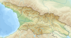 Gudamaqari Gudamaqari (Georgia) | |
| Coordinates: 42°26′16″N 44°45′00″E / 42.43778°N 44.75000°E An approximate geographical area. | |
| Country | |
| Mkhare | Mtskheta-Mtianeti |
| Capital | Tbilisi |


Gudamaq'ari (Gudamakari;[1] Georgian: გუდამაყარი) is a small historical geographic area in northeast Georgia on the southern slopes of the Greater Caucasus Mountains. Located along the river valley of Aragvi, it is bordered by Mtiuleti on the west, Khevi on the north, Khevsureti and Pshavi on the east, and Khando and Ch'artali communities on the south. Gudamaq'ari is sometimes viewed as a part of Mtiuleti. Modern administrative subdivision of Georgia places the area in the Mtskheta-Mtianeti mkhare (region).
History
The inhabitants of Gudamaq’ari – Gudamaq’relebi (გუდამაყრელები) – are first chronicled by the 11th century Georgian historian Leonti Mroveli in connection with the conversion of Iberia/Kartli by St. Nino in the 330s.[2] A strategic road running through this area played an important role in medieval Georgia and was much later, under the Imperial Russian rule, connected to the Georgian Military Road.[3][4][5]
References
- ^ Gudamakari Wikimapia
- ^ Wardrop, Margery (2007 [1900]), Life of Saint Nino, page 52. Gorgias Press LLC, ISBN 1-59333-471-0
- ^ Hearst Museum, Berkeley
- ^ Shorena Kurtsikidze & Vakhtang Chikovani, Ethnography and Folklore of the Georgia-Chechnya Border: Images, Customs, Myths & Folk Tales of the Peripheries, Munich: Lincom Europa, 2008.
- ^ Images from the Georgia-Chechnya Border, 1970-1980: Visual Anthropology of the Peripheries
This Georgia location article is a stub. You can help Wikipedia by expanding it. |