
| La Frontera Formation | |
|---|---|
| Stratigraphic range: Turonian ~ | |
| Type | Geological formation |
| Unit of | Villeta Group |
| Underlies | Conejo Formation |
| Overlies | Simijaca Fm., La Corona Gb. |
| Thickness | up to 206 metres (680 ft) |
| Lithology | |
| Primary | Lydite |
| Other | Limestone |
| Location | |
| Coordinates | 4°54′40″N 74°27′50″W / 4.91111°N 74.46389°W |
| Region | Altiplano Cundiboyacense Eastern Ranges, Andes |
| Country | |
| Type section | |
| Named for | La Frontera quarry |
| Named by | Cáceres & Etayo |
| Location | Albán |
| Year defined | 1969 |
| Coordinates | 4°54′40″N 74°27′50″W / 4.91111°N 74.46389°W |
| Region | Cundinamarca, Boyacá |
| Country | |
 Paleogeography of Northern South America 90 Ma, by Ron Blakey | |
The La Frontera Formation (Spanish: Formación La Frontera, K2F, Ksf) is a geological formation, part of the Villeta Group, of the Altiplano Cundiboyacense and neighbouring areas of the Eastern Ranges of the Colombian Andes. The sequence of limestones and lydites dates to the Late Cretaceous period; Turonian epoch and has a maximum thickness of 206 metres (676 ft).
Fossils of Yaguarasaurus columbianus were said to be found in this formation (listed as "La Frontera Member"), although the geological mapping of the area state the time-equivalent Hondita Formation as the stratigraphic unit present in the Quebradas El Ocal and Itaibe in Huila. The La Frontera Formation does not outcrop south of Cundinamarca. A high diversity of ammonites has been found in the La Frontera Formation.
YouTube Encyclopedic
-
1/3Views:8 347 080921 0185 340 658
-
Canada & The United States (Bizarre Borders Part 2)
-
War and Nation Building in Latin America: Crash Course World History 225
-
The JFK Assassination: Conspiracy, Photos, Facts, Autopsy, Documentary Evidence (2007)
Transcription
Canada and the United States share the longest, straightest, possibly boringest border in the world. But, look closer, and there's plenty of bizarreness to be found. While these sister nations get along fairly well, they both want to make it really clear whose side of the continent is whose. And they've done this by carving a 20-foot wide space along the border. All five and a half thousand miles of it. With the exception of the rare New England town that predates national borders or the odd airport that needed extending, this space is the no-touching-zone between the countries and they're super serious about keeping it clear. It matters not if the no-touching-zone runs through hundreds of miles of virtually uninhabited Alaskan / Yukon wilderness. Those border trees, will not stand. Which might make you think this must be the longest, straightest deforested place in the world, but it isn't. Deforested: yes, but straight? Not at all. Sure it looks straight and on a map, and the treaties establishing the line *say* it's straight... but in the real world the official border is 900 lines that zig-zags from the horizontal by as much as several hundred feet. How did this happen? Well, imagine you're back in North America in the 1800s -- The 49th parallel (one of those horizontal lines you see on a globe) has just been set as the national boundary and it's your job to make it real. You're handed a compass and a ball of string and told to carefully mark off the next 2/3rds of a continent. Don't mind that uncharted wilderness in the way: just keep the line straight. Yeah. Good luck. With that. The men who surveyed the land did the best they could and built over 900 monuments. They're in about as straight as you could expect a pre-GPS civilization to make, but it's not the kind of spherical / planar intersection that would bring a mathematician joy. Nonetheless these monuments define the border and the no-touching-zone plays connect-the-dots with them. Oh, and while there are about 900 markers along this section of the border, there are about 8,000 in total that define the shape of the nations. Despite this massive project Canada and the United States still have disputed territory. There is a series of islands in the Atlantic that the United States claims are part of Maine and Canada claims are part of New Brunswick. Canada, assuming the islands are hers built a lighthouse on one of them, and the United States, assuming the islands are hers pretends the lighthouse doesn't exist. It's not a huge problem as the argument is mostly over tourists who want to see puffins and fishermen who want to catch lobsters, but let's hope the disagreement gets resolved before someone finds oil under that lighthouse. Even the non-disputed territory has a few notably weird spots: such as this tick of the border upward into Canada. Zoom in and it gets stranger as the border isn't over solid land but runs through a lake to cut off a bit of Canada before diving back down to the US. This spot is home to about 100 Americans and is a perfect example of how border irregularities are born: Back in 1783 when the victorious Americans were negotiating with the British who controlled what would one day be Canada, they needed a map, and this map was the best available at the time. While the East Coast looks pretty good, the wester it goes the sparser it gets. Under negotiation was the edge of what would one day be Minnesota and Manitoba. But unfortunately, that area was hidden underneath an inset on the map, so the Americans and British were bordering blind. Seriously. They guessed that the border should start from the northwestern part of this lake and go in a horizontal line until it crossed the Mississippi... somewhere. But somewhere, turned out to be nowhere as the mighty Mississippi stops short of that line, which left the border vague until 35 years later when a second round of negotiations established the aforementioned 49th parallel. But there was still a problem as the lake mentioned earlier was both higher, and less circular than first though, putting its northwesterly point here so the existing border had to jump up to meet it and then drop straight down to the 49th, awkwardly cutting off a bit of Canada, before heading west across the remainder of the continent. Turns out you just can't draw a straight(-ish) line for hundreds of miles without causing a few more problems. One of which was luckily spotted in advance: Vancouver Island, which the 49th would have sliced through, but both sides agreed that would be dumb so the border swoops around the island. However, next door to Vancouver Island is Point Roberts which went unnoticed as so today the border blithey cuts across. It's a nice little town, home to over 1,000 Americans, but has only a primary school so its older kids have to cross international borders four times a day to go to school in their own state. In a pleasing symetry, the East cost has the exact opposite situation with a Canadian Island whose only land route is a bridge to the United States. And these two aren't the only places where each country contains a bit of the other: there are several more, easily spotted in sattelite photos by the no-touching zone. Regardless of if the land in question is just an uninhabited strip, in the middle of a lake, in the middle of nowhere, the border between these sister nations must remain clearly marked.
Etymology
The formation was first described by Hubach in 1931 and elevated to formation in 1969 by Cáceres and Etayo.[1] The formation is named after the quarry La Frontera near Albán, Cundinamarca.[2]
Description
Lithologies
The La Frontera Formation is characterised by a lower part consisting of limestones and an upper part comprising lydites.[1]
Stratigraphy and depositional environment
The La Frontera Formation overlies the Simijaca Formation and is overlain by the Conejo Formation, all units belong to the Villeta Group. The age has been estimated to be Turonian.[1] Stratigraphically, the formation is time equivalent with the Chipaque, Hondita and La Luna Formations.[3] The formation has been deposited in an open marine platform to submarine fan setting.[4] The deposition is represented by a maximum flooding surface.[5] The formation contains concretions and a high diversity of ammonites;[6] Wrightoceras munieri, Vascoceras cf. constrictum, Vascoceras cf. venezolanum, Kamerunoceras sp., Kamerunoceras cf. turoniense, Hoplitoides cf. lagiraldae, Codazziceras ospinae, Coilopoceras cf. newelli,[7] Hoplitoides wohltmanni, Neoptychites crassus, Hoplitoides ingens, Mammites sp., ?Fagesia sp., and Prionocycloceras sp.[8] Also the bivalves Anomia colombiana and Inoceramus sp. have been found in the La Frontera Formation.[2]
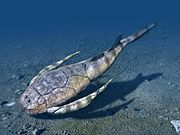
Yaguarasaurus
Fossils of Yaguarasaurus columbianus were described as coming from the "La Frontera Member", part of the "Villeta Formation", in the Quebrada El Ocal, 26 kilometres (16 mi) southwest of Neiva, Huila,[9][10] and in the Quebrada Itaibe 78 kilometres (48 mi) southwest of Neiva,[11] although in these areas the time-equivalent Hondita Formation is mapped.[12][13]
Outcrops

The La Frontera Formation is apart from its type locality, found at surface in the north of the Bogotá savanna, in the Tabio anticlinal, along the road Ubaté-Carmen de Carupa,[1] north and east of Chiquinquirá,[14] south of Cachipay,[15] to a thin band east of Viotá.[16]
Regional correlations
| Age | Paleomap | VMM | Guaduas-Vélez | W Emerald Belt | Villeta anticlinal | Chiquinquirá- Arcabuco |
Tunja- Duitama |
Altiplano Cundiboyacense | El Cocuy | ||||
|---|---|---|---|---|---|---|---|---|---|---|---|---|---|
| Maastrichtian |  |
Umir | Córdoba | Seca | eroded | Guaduas | Colón-Mito Juan | ||||||
| Umir | Guadalupe | ||||||||||||
| Campanian | Córdoba | ||||||||||||
| Oliní | |||||||||||||
| Santonian | La Luna | Cimarrona - La Tabla | La Luna | ||||||||||
| Coniacian | Oliní | Villeta | Conejo | Chipaque | |||||||||
| Güagüaquí | Loma Gorda | undefined | La Frontera | ||||||||||
| Turonian |  |
Hondita | La Frontera | Otanche | |||||||||
| Cenomanian | Simití | hiatus | La Corona | Simijaca | Capacho | ||||||||
| Pacho Fm. | Hiló - Pacho | Churuvita | Une | Aguardiente | |||||||||
| Albian |  |
Hiló | Chiquinquirá | Tibasosa | Une | ||||||||
| Tablazo | Tablazo | Capotes - La Palma - Simití | Simití | Tibú-Mercedes | |||||||||
| Aptian | Capotes | Socotá - El Peñón | Paja | Fómeque | |||||||||
| Paja | Paja | El Peñón | Trincheras | Río Negro | |||||||||
| La Naveta | |||||||||||||
| Barremian | 
| ||||||||||||
| Hauterivian | Muzo | Cáqueza | Las Juntas | ||||||||||
| Rosablanca | Ritoque | ||||||||||||
| Valanginian | Ritoque | Furatena | Útica - Murca | Rosablanca | hiatus | Macanal | |||||||
| Rosablanca | |||||||||||||
| Berriasian |  |
Cumbre | Cumbre | Los Medios | Guavio | ||||||||
| Tambor | Arcabuco | Cumbre | |||||||||||
| Sources | |||||||||||||
See also
References
- ^ a b c d Montoya & Reyes, 2005, p.24
- ^ a b Acosta & Ulloa, 2001, p.41
- ^ Montoya & Reyes, 2005, p.26
- ^ García González et al., 2009, p.218
- ^ Villamil, 2012, p.164
- ^ Villamil, 2012, p.181
- ^ Patarroyo, 2016, p.41
- ^ Blanco et al., 2004, p.26
- ^ 'Yaguarasaurus columbianus' in the Paleobiology Database
- ^ Yaguarasaurus columbianus at Fossilworks.org
- ^ Páramo Fonseca, 2000, p.124
- ^ Plancha 344, 1999
- ^ Plancha 345, 1999
- ^ Plancha 190, 2009
- ^ Plancha 227, 1998
- ^ Plancha 246, 1998
Bibliography
- Acosta Garay, Jorge, and Carlos E. Ulloa Melo. 2001. Geología de la Plancha 208 Villeta - 1:100,000, 1-84. INGEOMINAS. Accessed 2017-04-04. Archived 2017-03-24 at the Wayback Machine
- Blanco, Johana Paola; Paula Andrea Medina, and Pedro Patarroyo. 2004. La Formación La Frontera, Sección Vereda Tóriba: Una propuesta para la designación del Lectoestratotipo. Geología Colombiana 29. 23-40. Accessed 2017-04-04. Archived 2017-04-05 at the Wayback Machine
- García González, Mario; Ricardo Mier Umaña; Luis Enrique Cruz Guevara, and Mauricio Vásquez. 2009. Informe Ejecutivo - evaluación del potencial hidrocarburífero de las cuencas colombianas, 1-219. Universidad Industrial de Santander.
- Montoya Arenas, Diana María, and Germán Alfonso Reyes Torres. 2005. Geología de la Sabana de Bogotá, 1–104. INGEOMINAS.
- Páramo Fonseca, María Euridice. 2000. Yaguarasaurus columbianus (Reptilia, Mosasauridae), a primitive mosasaur from the Turonian (Upper Cretaceous) of Colombia. Historical Biology 14. 121-131. Accessed 2018-05-30.
- Patarroyo, Pedro. 2016. Amonoideos y otros macrofósiles del lectoestratotipo de la Formación la Frontera, Turoniano inferior - medio (Cretácico Superior) en San Francisco, Cundinamarca (Colombia). Boletín de Geología, Universidad Industrial de Santander 38. 41-54. Accessed 2017-04-04.
- Villamil, Tomas. 2012. Chronology Relative Sea Level History and a New Sequence Stratigraphic Model for Basinal Cretaceous Facies of Colombia, 161–216. Society for Sedimentary Geology (SEPM).
Maps La Frontera Fm. proper
- Ulloa, Carlos E, and Erasmo Rodríguez. 2009. Plancha 170 - Vélez - 1:100,000, 1. INGEOMINAS. Accessed 2017-06-06.
- Fuquen M., Jaime A, and José F. Osorno M. 2009. Plancha 190 - Chiquinquirá - 1:100,000, 1. INGEOMINAS. Accessed 2017-06-06.
- Ulloa, Carlos, and Jorge Acosta. 1998. Plancha 208 - Villeta - 1:100,000, 1. INGEOMINAS. Accessed 2017-06-06.
- Montoya, Diana María, and Germán Reyes. 2009. Plancha 209 - Zipaquirá - 1:100,000, 1. INGEOMINAS. Accessed 2017-06-06.
- Ulloa, Carlos E; Erasmo Rodríguez, and Jorge E. Acosta. 1998. Plancha 227 - La Mesa - 1:100,000, 1. INGEOMINAS. Accessed 2017-06-06.
- Acosta, Jorge E., and Carlos E. Ulloa. 1998. Plancha 246 - Fusagasugá - 1:100,000, 1. INGEOMINAS. Accessed 2017-06-06.
Maps Yaguarasaurus locations
- Marquínez, Germán; C. Morales, and Alberto Núñez. 1999. Plancha 344 - Tesalia - 1:100,000, 1. INGEOMINAS. Accessed 2017-06-06.
- Velandia, F.; C.J. Morales; J.C. Caicedo, and Alberto Núñez. 1999. Plancha 345 - Campoalegre - 1:100,000, 1. INGEOMINAS. Accessed 2017-06-06.
External links
- Gómez, J.; N.E. Montes; Á. Nivia, and H. Diederix. 2015. Plancha 5-09 del Atlas Geológico de Colombia 2015 – escala 1:500,000, 1. Servicio Geológico Colombiano. Accessed 2017-04-04.

