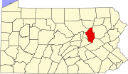
This is a list of the Pennsylvania state historical markers in Columbia County.
This is intended to be a complete list of the official state historical markers placed in Columbia County, Pennsylvania by the Pennsylvania Historical and Museum Commission (PHMC). The locations of the historical markers, as well as the latitude and longitude coordinates as provided by the PHMC's database, are included below when available. There are eight historical markers located in Columbia County.[1]
YouTube Encyclopedic
-
1/3Views:8451 4253 388
-
Clovis culture
-
Lewis Powell (conspirator)
-
Interstate Highway System
Transcription
Historical markers
| Marker title | Image | Date dedicated | Location | Marker type | Topics |
|---|---|---|---|---|---|
| Catawissa Friends Meeting | 
|
May 8, 1948 | Junction U.S. 11 & Pa. 42, .7 mile SW of Bloomsburg |
Roadside | Buildings, Early Settlement, Religion |
| Catawissa Friends Meeting | 
|
May 1, 1948 | South St. between 3rd & 4th Sts., Catawissa 40°57′03″N 76°27′41″W / 40.95087°N 76.46143°W |
Roadside | Buildings, Early Settlement, Religion |
| Columbia County | 
|
July 11, 1983 | County Courthouse, Main St., Bloomsburg 41°00′11″N 76°27′25″W / 41.00305°N 76.45707°W |
City | Bridges, Cities & Towns, Government & Politics, Government & Politics 19th Century, Religion |
| Fishing Creek confederacy | 
|
July 26, 2009 | 90 Mill St. (PA 487), Benton, PA 41°11′30″N 76°23′01″W / 41.1918°N 76.3836°W |
Roadside | Abraham Lincoln, Civil War, Forts, Government & Politics 19th Century, Military |
| Fort Jenkins | 
|
May 8, 1948 | Old U.S. 11, 6.5 miles NE of Bloomsburg |
Roadside | American Revolution, Forts, Government & Politics 18th Century, Military, Native American |
| Fort McClure | 
|
May 8, 1948 | U.S. 11 at Fairgrounds, Bloomsburg |
Roadside | American Revolution, Early Settlement, Forts, Military, Native American |
| Fort Wheeler | 
|
May 10, 1948 | Pa. 487, 1.2 miles NE of Bloomsburg 41°01′32″N 76°25′46″W / 41.02542°N 76.42947°W |
Roadside | American Revolution, Forts, Military, Native American |
| Wyoming Path | 
|
May 3, 1949 | W 2nd St. (US 11) near W Ft. McClure Blvd., at Fairgrounds, Bloomsburg 40°59′40″N 76°28′23″W / 40.99448°N 76.4731°W |
Roadside | Native American, Paths & Trails, Religion, Transportation |
See also
- List of Pennsylvania state historical markers
- National Register of Historic Places listings in Columbia County, Pennsylvania
References
- ^ "PHMC Historical Markers Search" (Searchable database). Pennsylvania Historical and Museum Commission. Commonwealth of Pennsylvania. Retrieved 2010-07-19.


