
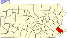
This is a list of the Pennsylvania state historical markers in Montgomery County.
This is intended to be a complete list of the official state historical markers placed in Montgomery County, Pennsylvania by the Pennsylvania Historical and Museum Commission (PHMC). The locations of the historical markers, as well as the latitude and longitude coordinates as provided by the PHMC's database, are included below when available. There are 60 historical markers located in Montgomery County.[1]
YouTube Encyclopedic
-
1/5Views:21 37212 0673 7622 5111 137
-
2017 05 02 Tim Wise - Beyond Diversity
-
The Grand Review and Demobilization of the Armies (Lecture)
-
Lewis Powell (conspirator)
-
Improve Vocabulary ★ Sleep Learning ★ Listen To Spoken English Conversation, Binaural Beats Part 24✔
-
The Age of Innocence Audiobook by Edith Wharton | Audio book with subtitles
Transcription
Historical markers
| Marker title | Image | Date dedicated | Location | Marker type | Topics |
|---|---|---|---|---|---|
| Abington Presbyterian Church | 
|
May 24, 1992 | Old York & Susquehanna Sts., Abington 40°06′51″N 75°07′19″W / 40.11418°N 75.1219°W |
City | Religion |
| Ashbridge Memorial Park | 1700's | Near Shipley | Roadside | Civil War, Rebecca Emily | |
| Augustus Lutheran Church | 
|
September 3, 1947 | Main St. (old U.S. 422) in Trappe 40°12′04″N 75°28′52″W / 40.20115°N 75.4812°W |
Roadside | Religion |
| Baldwin School | 
|
April 11, 2000 | 701 Montgomery Ave., Bryn Mawr | Roadside | Buildings, Education, Railroads |
| Bert Bell | 
|
November 22, 1997 | 224-226 Haverford Ave., Narberth 40°00′19″N 75°15′40″W / 40.00537°N 75.26103°W |
City | Football, Sports |
| Beth Sholom Synagogue | 
|
September 21, 2008 | 8231 Old York Rd., Elkins Park 40°04′54″N 75°07′36″W / 40.0818°N 75.1268°W |
City | Buildings, Religion |
| Betzwood Motion Picture Studio | June 3, 2003 | Near Route 363 and Route 422 expressway, Norristown | City | Business & Industry, Invention, Motion Pictures & Television | |
| Bryn Athyn Cathedral | 
|
September 10, 1947 | Pa. 232 in Bryn Athyn at Cathedral | Roadside | Religion |
| Bryn Mawr Summer School for Women Workers in Industry | 
|
October 13, 2001 | Bryn Mawr Campus, Corner of Morris Road and Yarrow Streets 40°01′27″N 75°18′50″W / 40.0241°N 75.31388°W |
Roadside | African American, Civil Rights, Education, Ethnic & Immigration, Labor, Women |
| Camp William Penn | 
|
May 15, 1999 | 7322 Sycamore Ave., LaMott 40°03′59″N 75°08′32″W / 40.06635°N 75.1423°W |
Roadside | African American, Civil War, Military |
| Charles Thomson | 
|
September 10, 1947 | SR 3034 (Morris Ave. at Harriton Rd.), NE, of Bryn Mawr (Missing) | Roadside | Ethnic & Immigration, Government & Politics, Government & Politics 18th Century |
| Crooked Billet | 
|
May 1, 1965 | Meadowbrook Ave. at Crooked Billet Elem. School in Hatboro | Roadside | American Revolution, Military, Inns & Taverns |
| Cyrus H. K. Curtis (1850-1933) | 
|
November 7, 2005 | 1250 W Church Rd., Wyncote (SR73) 40°05′13″N 75°08′58″W / 40.08693°N 75.14942°W |
Roadside | Entrepreneurs, Environment, Publishing |
| Early Grist Mill | May 2, 1955 | Pa. 320 at Gulph Mills (Missing) | City | Buildings, Business & Industry, Mills | |
| Early Tavern | 
|
September 14, 1972 | General Wayne Inn, 625 Montgomery Ave., Narberth | Roadside | Business & Industry, George Washington, Inns & Taverns, William Penn |
| Edward Hector | September 19, 1967 | Intersection SR 3016 & 3013 (Fayette & Hector Sts.), Conshohocken 40°04′24″N 75°18′24″W / 40.07328°N 75.30668°W |
Roadside | African American, American Revolution, Military | |
| Falkner Swamp Reformed Church | 
|
October 9, 1960 | Swamp Pike (county highway, Limerick to Gilbertsville), .5 mile SE of New Hanover 40°17′46″N 75°34′48″W / 40.2961°N 75.58013°W |
Roadside | Buildings, Ethnic & Immigration, Religion |
| First Iron Bridge | May 21, 1953 | SE corner, High & York Sts., Pottstown 40°14′45″N 75°39′09″W / 40.24588°N 75.65263°W |
City | Bridges, Iron, Railroads, Transportation | |
| Frank N.D. Buchman | October 19, 1991 | 772 Main St. (Pa. 29), Pennsburg | Roadside | Professions & Vocations, Religion | |
| Frederick A. C. Muhlenberg (1750-1801) | 
|
April 12, 2008 | 151 W Main St., Trappe | Roadside | Government & Politics, Government & Politics 18th Century, Religion |
| Gen. Andrew Porter | March 11, 1949 | W. Main & Selma Sts., Norristown 40°07′21″N 75°21′38″W / 40.12258°N 75.36063°W |
Roadside | American Revolution, Military | |
| Graeme Park | 
|
n/a | At site, SR 2038 (County Line Road), 1 mile NW of Pa. 611, Hatboro (Missing) | Roadside | Environment, Government & Politics 18th Century |
| Gulph Mills Encampment | May 2, 1955 | Pa. 320 near intersection SR 3030 at Gulph Mills (Missing) | City | American Revolution, Military | |
| Gulph Mills Village | 
|
November 9, 1982 | Intersection Pa. 320 & SR 3039 (Gulph Rd.), Gulph Mills 40°03′47″N 75°20′29″W / 40.06293°N 75.34125°W |
City | Buildings, Houses & Homesteads, Inns & Taverns |
| Harold F. Pitcairn | 
|
April 29, 1972 | Buck & Paper Mill Rds., Bryn Athyn 40°07′55″N 75°03′30″W / 40.132°N 75.05835°W |
Roadside | Invention, Medicine & Science, Professions & Vocations, Transportation |
| Harriton | 
|
June 12, 1963 | SR 3034 (Morris Ave. at Harriton Rd.), NE of Bryn Mawr | City | Government & Politics, Government & Politics 18th Century, Houses & Homesteads |
| Hope Lodge | 
|
February 16, 1966 | At site, Old Bethlehem Pike (SR 2018), Fort Washington 40°07′30″N 75°13′03″W / 40.12495°N 75.21753°W |
Roadside | Buildings, Houses & Homesteads |
| James A. Bland | 
|
September 26, 1961 | Pa. 23 (Conshohocken State Rd.), Bala Cynwyd | City | African American, Music & Theater, Performers |
| John Dickinson | 
|
September 23, 2001 | Montgomery Avenue & Meetinghouse Lane, Merion (MISSING) | Roadside | American Revolution, Government & Politics 18th Century, Military |
| John F. Hartranft | 
|
May 6, 1947 | Sanatoga Rd., SW of Fagleysville 40°16′17″N 75°34′24″W / 40.27137°N 75.57325°W |
Roadside | Civil War, Government & Politics, Government & Politics 19th Century, Governors, Military |
| John F. Hartranft |
|
September 4, 1947 | SR 4031 (High St., old U.S. 422), Sanatoga (Missing) | Roadside | Civil War, Government & Politics, Government & Politics 19th Century, Governors, Military |
| Keith House | 
|
1947 | At Graeme Park, County Line Rd., 1 mile NW of Pa. 611, Hatboro 40°13′07″N 75°09′02″W / 40.21854°N 75.15049°W |
Roadside | Government & Politics, Government & Politics 18th Century, Houses & Homesteads |
| Lafayette | 
|
October 7, 1980 | 801 Ridge Pike, Barren Hill, E of Conshohocken 40°46′56″N 75°14′59″W / 40.7823°N 75.24968°W |
Roadside | American Revolution, Military |
| Lucretia C. Mott | 
|
May 1, 1974 | Pa. 611 N of Cheltenham Ave., Elkins Park 40°03′52″N 75°08′08″W / 40.06442°N 75.13548°W |
Roadside | Civil Rights, Government & Politics, Government & Politics 19th Century, Religion, Underground Railroad, Women |
| Merion Friends Meeting | 
|
September 15, 1967 | 651 Montgomery Ave., Narberth 40°00′33″N 75°15′15″W / 40.0093°N 75.25418°W |
City | Buildings, Ethnic & Immigration, Religion, William Penn |
| Mill Grove | 
|
October 9, 1970 | Entrance to Audubon Wildlife Sanctuary, Audubon & Pawlings Rds. (SR 4041 & 4004), Audubon 40°07′24″N 75°26′13″W / 40.12337°N 75.43708°W |
Roadside | Artists, Buildings, Environment, Mansions & Manors, Writers |
| Muhlenberg Home | 
|
October 3, 1963 | E. 7th Ave., .3 mile from Main St. (old U.S. 422), Trappe (Missing) 40°11′47″N 75°28′12″W / 40.1963°N 75.46987°W |
Roadside | Education, Government & Politics, Government & Politics 18th Century |
| Muhlenberg House | 
|
April 28, 1960 | 201 Main St. (old U.S. 422), Trappe | City | American Revolution, Religion |
| New Goschenhoppen Reformed Church | 
|
August 26, 1952 | SR 1042 (Church Rd.), W of East Greenville | Roadside | Buildings, Religion |
| New Hanover Lutheran Church | 
|
September 8, 1950 | Swamp Pike (county highway), at Lutheran Rd., near Gilbertsville Golf Course, .2 mile SE of New Hanover 40°17′53″N 75°34′54″W / 40.29793°N 75.58173°W |
Roadside | Buildings, Ethnic & Immigration, Religion |
| Pennsylvania School of Horticulture for Women, The | 
|
September 20, 2002 | 580 Meetinghouse Road, Ambler | Roadside | Agriculture, Education, Military, Women |
| Pennypacker's Mill & Mansion | 
|
September 24, 1946 | At site, Skippack Pike (PA 73) and Haldeman Rd., Schwenksville 40°15′10″N 75°27′31″W / 40.25267°N 75.45862°W |
Roadside | George Washington, Government & Politics, Government & Politics 18th Century, Governors |
| Perkiomen Bridge | 
|
September 4, 1947 | E Main St. / Ridge Pike (SR 4031 / old U.S. 422) at bridge, E end of Collegeville 40°11′03″N 75°26′50″W / 40.18428°N 75.44717°W |
Roadside | Bridges, Transportation |
| Philo T. Farnsworth (1906-1971) | 
|
September 15, 2006 | 1260 E Mermaid Lane, Wyndmoor 40°04′59″N 75°10′55″W / 40.08318°N 75.18202°W |
City | Business & Industry, Invention |
| Plymouth Friends Meetinghouse | 
|
May 15, 1955 | Germantown Pike (old U.S. 422) & Butler Pike at Plymouth Meeting 40°06′10″N 75°16′44″W / 40.10272°N 75.27882°W |
Roadside | African American, American Revolution, Buildings, George Washington, Religion |
| Porter Home | September 3, 1947 | U.S. 422 at Norristown (Missing) | Roadside | American Revolution, Government & Politics 19th Century, Military | |
| Pottsgrove Manor | 
|
September 25, 2000 | At site, 100 W. King St., Pottstown 40°14′52″N 75°39′36″W / 40.24788°N 75.65995°W |
Roadside | Buildings, Business & Industry, Iron, Mansions & Manors |
| Rittenhouse Farm | September 3, 1947 | Pa. 363 E of Eagleville, intersection SR 3009 (Ridge Pike) & 3002 (Trooper Rd.), Norristown 40°08′31″N 75°23′21″W / 40.14187°N 75.38915°W |
Roadside | Medicine & Science, Professions & Vocations | |
| Rittenhouse Farm | March 14, 1949 | Germantown Pike (former U.S. 422) at Valley Forge Medical Ctr., 6 miles SE of Collegeville (Missing) | Roadside | Medicine & Science, Professions & Vocations | |
| Selma | 
|
March 15, 1949 | 1301 W. Airy St., Norristown 40°07′24″N 75°21′36″W / 40.12328°N 75.36°W |
Roadside | American Revolution, Military |
| St. Paul's Episcopal Church | 
|
October 1, 1992 | Old York Rd. (PA 611) at Asbourne Rd., Elkins Park 40°04′17″N 75°08′00″W / 40.07148°N 75.13347°W |
Roadside | Buildings, Civil War, Religion |
| St. Peter's Church | November 9, 1963 | Church Rd., off Germantown Pike (old U.S. 422) 5 miles E of Norristown 40°04′58″N 75°15′03″W / 40.08287°N 75.25095°W |
Roadside | American Revolution, Buildings, Religion | |
| Thomas Rowland & Sons Shovel Works | 
|
October 21, 2006 | 300 Ashbourne Rd., Cheltenham | Roadside | Business & Industry, Mills |
| Timothy Matlack | 
|
June 4, 1969 | Pawlings Rd. (SR 4004) near Audubon Rd. (SR 4041) at Audubon 40°07′19″N 75°26′23″W / 40.122°N 75.43975°W |
Roadside | American Revolution, Government & Politics, Government & Politics 18th Century, Religion |
| Village of La Mott | 
|
June 1973 | PA 309 (Cheltenham Ave.) just NW of Pa. 611 | Roadside | African American, Cities & Towns, Civil War, Military, William Penn |
| Wall House (The Ivy) | 
|
November 21, 1982 | Wall Park Dr. & Church Rd., Elkins Park | Roadside | Houses & Homesteads, Religion, William Penn |
| Whitemarsh | 
|
December 22, 1947 | SR 2027 (Pennsylvania Ave.) just E of Pa. 309, SE of Fort Washington 40°07′27″N 75°11′33″W / 40.12425°N 75.19247°W |
Roadside | American Revolution, George Washington, Houses & Homesteads, Military |
| William B. T. Trego (1858-1909) | 
|
September 20, 2008 | 509 E Montgomery Ave., North Wales 40°12′48″N 75°16′29″W / 40.21345°N 75.2748°W |
City | Artists, Military |
| Winfield S. Hancock | 
|
September 11, 1947 | Pa. 309 S of Montgomeryville | Roadside | Civil War, Military |
| Woodrow Wilson | 
|
November 1, 1958 | New Gulph Rd. at entrance to college, near Caversham Rd., Bryn Mawr 40°01′42″N 75°18′45″W / 40.0282°N 75.31242°W |
City | Education, Government & Politics, Government & Politics 19th Century, Government & Politics 20th Century |
See also
- List of Pennsylvania state historical markers
- National Register of Historic Places listings in Montgomery County, Pennsylvania
References
- ^ "PHMC Historical Markers Search" (Searchable database). Pennsylvania Historical and Museum Commission. Commonwealth of Pennsylvania. Retrieved 2010-07-19.

