


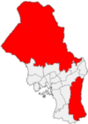
Marka is the name of the forested and hilly areas surrounding Oslo, Norway. It includes areas within the municipality of Oslo, but also large areas in Hole, Ringerike in Buskerud county and Jevnaker, Lunner, Nittedal, Bærum, Asker, and other municipalities in Akershus county. The name is actually just the finite form of mark (Norse mǫrk f) 'woodland, forest'. (See also Finnmark, Hedmark, Telemark, Marker and Aremark.)[2]
Though not designated a borough of Oslo, it is a major recreational area for the population of Oslo, and development in the area is for the most part prohibited. Despite being used frequently by many inhabitants of Oslo, especially at weekends, the fauna of marka includes species such as lynx, wolf, beaver, moose and roe deer.
The term Oslomarka is usually used for all the recreational areas around Oslo. Marka is the administrative name for the part of it that lies inside the city limits. Neighboring municipalities (most of which lie in Viken) do not have the same kind of administrative division as Oslo, and thus do not have any separate administrative arrangement for their parts of the area. The area within Oslo municipality is divided into two parts. The population and agricultural areas of Marka are located mainly in two valleys, Sørkedalen and Maridalen.
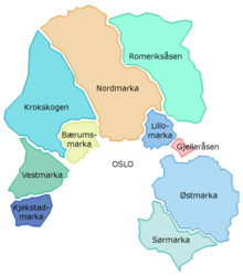
Oslomarka is further divided into:
- Kjekstadmarka[3]
- Vestmarka
- Krokskogen
- Bærumsmarka
- Nordmarka
- Romeriksåsen[4]
- Lillomarka
- Gjelleråsen
- Østmarka
- Sørmarka[5]
Of these, Vestmarka, Kjekstadmarka, Romeriksåsene, Follomarka and Sørmarka lie almost entirely outside the city limits.
60°01′06″N 10°42′02″E / 60.0182°N 10.7006°E
YouTube Encyclopedic
-
1/1Views:2 865
-
Visit Oslomarka - The Autumn Arrives Østmarka
Transcription
References
- ^ Municipality of Oslo (2020). "Befolkningen etter bydel, kjønn og aldersgrupper 1.1.2020" (in Norwegian). Retrieved 29 April 2020.
- ^ Knut Are Tvedt. "Oslomarka". Store norske leksikon. Retrieved September 15, 2016.
- ^ Svein Askheim. "Kjekstadmarka". Store norske leksikon. Retrieved September 15, 2016.
- ^ Svein Askheim. "Romeriksåsene". Store norske leksikon. Retrieved September 15, 2016.
- ^ Knut Are Tvedt. "Sørmarka". Store norske leksikon. Retrieved September 15, 2016.