
| Nabha State | |||||||||||
|---|---|---|---|---|---|---|---|---|---|---|---|
| Princely State | |||||||||||
| 1763–1947 | |||||||||||
 Flag
 Coat of arms
| |||||||||||
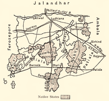 Nabha State in a 1911 map of Ludhiana district | |||||||||||
| Area | |||||||||||
• 1901 | 2,502 km2 (966 sq mi) | ||||||||||
| Population | |||||||||||
• 1901 | 297,949 | ||||||||||
| Historical era | New Imperialism | ||||||||||
• Established | 1763 | ||||||||||
• Accession to the Dominion of India | 1947 | ||||||||||
| |||||||||||
| Today part of | India | ||||||||||

Nabha State,[1] with its capital at Nabha, was one of the Phulkian princely states of Punjab during the British Raj in India.[2] Nabha was ruled by Jat Sikhs of the Sidhu clan.[3]
YouTube Encyclopedic
-
1/5Views:92087 2762 098110 3033 034
-
Badbar Nabha State Patiala || PK VIRSA BY RANA FAROOQ TAHIR ||
-
ਨਾਭੇ ਦਾ ਅਮੀਰ ਇਤਿਹਾਸ || Maharajas of Nabha || Ankurdeep Kaur || NewsNumber.Com
-
ਸ਼ਾਹੀ ਸਮਾਧਾਂ ਨਾਭਾ | Phulkian Dynasty
-
| Hira Mahal | Nabha Riyaasat ke Hira Mahal ki Full Documentary | नाभा रियासत की कहानी |
-
stamp collecting, collection, victoria india "nabha state service" 35/120
Transcription
History
Origin
The ruling house of Nabha belonged to the Phulkian dynasty, sharing a common ancestor named Tiloka with the Jind rulers. Tiloka was the eldest son of Phul Sidhu of the Phulkian Misl. The Nabha rulers descend from Gurditta (Gurdit Singh), the elder son of Tiloka. Gurditta was the founder of the localities of Dhanaula and Sangrur. Sangrur was the headquarters of the state till it was captured by Jind State. Gurditta died in 1754, his only son Surat (or Suratya) Singh had died two years earlier in 1752, leaving his grandson, Hamir Singh, as the next in line. Hamir Singh was the founder of the locality of Nabha and the first ruler of Nabha State.[4]
List of rulers
| No. | Name
(Birth–Death) |
Portrait | Reign | Enthronement | Ref. |
|---|---|---|---|---|---|
| Sardars | |||||
| 1 | Hamir Singh (died 1783) |

|
1754 – 1783 | ? | [4] |
| Rajas | |||||
| 2 | Jaswant Singh (1775 – 22 May 1840) |

|
1783 – 1840 | ? | [4] |
| 3 | Devinder Singh (5 September 1822 – 14/15 November 1865) |

|
1840 – 1846 | 15 October 1840 | [4] |
| 4 | Bharpur Singh (5 October 1840 – 9 November 1863) |

|
1846 – 1863 | ? | [4] |
| 5 | Bhagwan Singh (30 November 1842 – 31 May 1871) |
_standing_in_an_interior.webp)
|
1863 – 1871 | 17 February 1864 | [4] |
| Maharajas | |||||
| 6 | Hira Singh (19 December 1843 – 24 December 1911) |

|
1871 – 1911 | 10 August 1871 | [4] |
| 7 | Ripudaman Singh (4 March 1883 – 14 December 1942) |

|
1911 – 1923 | 24 January 1912 | [4] |
| 8 | Partap Singh (21 September 1919 – 22 July 1995) |

|
1923 – 1948 | [4] | |
Demographics
| Religious group |
1901[5] | 1911[6][7] | 1921[8] | 1931[9] | 1941[10] | |||||
|---|---|---|---|---|---|---|---|---|---|---|
| Pop. | % | Pop. | % | Pop. | % | Pop. | % | Pop. | % | |
| Hinduism |
160,553 | 53.89% | 126,414 | 50.79% | 133,870 | 50.84% | 132,354 | 46.02% | 146,518 | 43.09% |
| Sikhism |
78,361 | 26.3% | 76,198 | 30.62% | 78,389 | 29.77% | 97,452 | 33.89% | 122,451 | 36.01% |
| Islam |
58,550 | 19.65% | 46,032 | 18.5% | 50,756 | 19.27% | 57,393 | 19.96% | 70,373 | 20.7% |
| Jainism |
476 | 0.16% | 238 | 0.1% | 278 | 0.11% | 309 | 0.11% | 480 | 0.14% |
| Christianity |
7 | 0% | 5 | 0% | 41 | 0.02% | 66 | 0.02% | 221 | 0.06% |
| Zoroastrianism |
2 | 0% | 0 | 0% | 0 | 0% | 0 | 0% | 0 | 0% |
| Buddhism |
0 | 0% | 0 | 0% | 0 | 0% | 0 | 0% | 0 | 0% |
| Judaism |
0 | 0% | 0 | 0% | 0 | 0% | 0 | 0% | 0 | 0% |
| Others | 0 | 0% | 0 | 0% | 0 | 0% | 0 | 0% | 1 | 0% |
| Total population | 297,949 | 100% | 248,887 | 100% | 263,334 | 100% | 287,574 | 100% | 340,044 | 100% |
| Note: British Punjab province era district borders are not an exact match in the present-day due to various bifurcations to district borders — which since created new districts — throughout the historic Punjab Province region during the post-independence era that have taken into account population increases. | ||||||||||
Gallery
-
 Photograph of Gurdwara Siropa Sahib in Nabha state, where historical Sikh relics and artefacts were kept for safe-keeping, published in Mahan Kosh (1930), ca.1920's
 -
 Photograph of the Hira Mahal building in Nabha state, published in Mahan Kosh (1930), ca.1920's
See also
- Patiala and East Punjab States Union
- Political integration of India
- Phulkian sardars
- Phulkian Misl
- Patiala State
- Jind State
- Faridkot State
- Malaudh
- Bhadaur
- Kaithal
- Cis-Sutlej states
Notes
- ^ 1931-1941: Including Ad-Dharmis
References
- ^ Imperial Gazetteer of India, v. 18, p. 271.
- ^ Chisholm, Hugh, ed. (1911). . Encyclopædia Britannica. Vol. 19 (11th ed.). Cambridge University Press. p. 147.
- ^ Bates, Crispin (26 March 2013). Mutiny at the Margins: New Perspectives on the Indian Uprising of 1857: Volume I: Anticipations and Experiences in the Locality. SAGE Publishing India. ISBN 978-81-321-1589-2.
- ^ a b c d e f g h i Singh, Bhagat (1993). "Chapter 14 - The Phulkian Misl". A History of the Sikh Misals. Publication Bureau, Punjabi University.
- ^ "Census of India 1901. [Vol. 17A]. Imperial tables, I-VIII, X-XV, XVII and XVIII for the Punjab, with the native states under the political control of the Punjab Government, and for the North-west Frontier Province". 1901. p. 34. JSTOR saoa.crl.25363739. Retrieved 30 March 2024.
- ^ "Census of India 1911. Vol. 14, Punjab. Pt. 2, Tables". 1911. p. 27. JSTOR saoa.crl.25393788. Retrieved 30 March 2024.
- ^ Kaul, Harikishan (1911). "Census Of India 1911 Punjab Vol XIV Part II". p. 27. Retrieved 30 March 2024.
- ^ "Census of India 1921. Vol. 15, Punjab and Delhi. Pt. 2, Tables". 1921. p. 29. JSTOR saoa.crl.25430165. Retrieved 30 March 2024.
- ^ "Census of India 1931. Vol. 17, Punjab. Pt. 2, Tables". 1931. p. 277. JSTOR saoa.crl.25793242. Retrieved 30 March 2024.
- ^ "Census of India, 1941. Vol. 6, Punjab". 1941. p. 42. JSTOR saoa.crl.28215541. Retrieved 30 March 2024.
External links
 Media related to Nabha State at Wikimedia Commons
| International | |
|---|---|
| National | |
30°22′N 76°09′E / 30.37°N 76.15°E