
Nersingen | |
|---|---|
 Church of Saint Dionysius in Oberfahlheim | |
 Coat of arms | |
Location of Nersingen within Neu-Ulm district 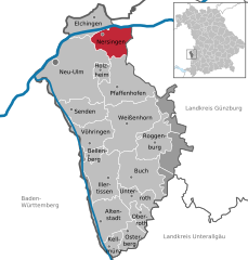 | |
 Nersingen  Nersingen | |
| Coordinates: 48°25′44″N 10°7′19″E / 48.42889°N 10.12194°E | |
| Country | Germany |
| State | Bavaria |
| Admin. region | Schwaben |
| District | Neu-Ulm |
| Subdivisions | 5 Ortsteile |
| Government | |
| • Mayor (2020–26) | Erich Winkler[1] |
| Area | |
| • Total | 24.27 km2 (9.37 sq mi) |
| Elevation | 465 m (1,526 ft) |
| Population (2022-12-31)[2] | |
| • Total | 9,611 |
| • Density | 400/km2 (1,000/sq mi) |
| Time zone | UTC+01:00 (CET) |
| • Summer (DST) | UTC+02:00 (CEST) |
| Postal codes | 89278 |
| Dialling codes | 07308 |
| Vehicle registration | NU |
| Website | www.nersingen.de |

Nersingen is a municipality in the District of Neu-Ulm in Bavaria, Germany. The neighbours are Neu-Ulm, Elchingen, Bibertal and Pfaffenhofen an der Roth.
Geography
Geographic location
Through the area of Nersingen flow three rivers: The Danube in the north and her both supply rivers, Roth and Leibi, which cross Nersingen from south to north. Also, there are some water ditches and some excavator lakes, which resulted from gravel quarrying. The most part of Nersingen is on the gravellic ground.
Municipality arrangement
The municipality of Nersingen consists of the principal village of Nersingen and the part villages Straß, Leibi, Unterfahlheim, and Oberfahlheim.
Economics and infrastructure
Companies
Hilti AG in Straß
Traffic
Nersingen lies next to the Bundesautobahn 7 and the train line Ulm - Munich. The Bundesstraße 10 passes the municipality parts Unterfahlheim, Oberfahlheim and Nersingen.
Education
There are two elementary schools and one elementary and principal school.
Objects of interest
- "Bräuhaus Seybold" in Nersingen
- "Museum für bildende Kunst" in Oberfahlheim
- Church "St. Johann Baptist" in Straß
- Church "St. Dionysius" in Oberfahlheim
- Church "St. Nikolaus" in Nersingen
References
- ^ Liste der ersten Bürgermeister/Oberbürgermeister in kreisangehörigen Gemeinden, Bayerisches Landesamt für Statistik, 15 July 2021.
- ^ Genesis Online-Datenbank des Bayerischen Landesamtes für Statistik Tabelle 12411-003r Fortschreibung des Bevölkerungsstandes: Gemeinden, Stichtag (Einwohnerzahlen auf Grundlage des Zensus 2011) (Hilfe dazu).
External links
- Official website
 (in German)
Towns and municipalities in Neu-Ulm (district) | ||
|---|---|---|
| International | |
|---|---|
| National | |
| Geographic | |