
State Route 95 | ||||
|---|---|---|---|---|
 | ||||
| Route information | ||||
| Maintained by ODOT | ||||
| Length | 89.04 mi[1] (143.30 km) | |||
| Existed | 1926–present | |||
| Major junctions | ||||
| West end | ||||
| East end | ||||
| Location | ||||
| Country | United States | |||
| State | Ohio | |||
| Counties | Marion, Morrow, Knox, Richland, Ashland, Wayne | |||
| Highway system | ||||
| ||||
| ||||
| ||||


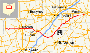
State Route 95 (SR 95) is an east–west state highway in the central part of the U.S. state of Ohio. Its western terminus is in LaRue at SR 37 and its eastern terminus is at SR 3 just south of Wooster.
YouTube Encyclopedic
-
1/3Views:6828 5574 471
-
Interstate 71 Southbound in Ohio Part 1
-
Pennsylvania Turnpike Travel: "Roads to Romance" 1951 Chevrolet
-
New York Harbor on Dallas-New York LGA flight: Statue of Liberty, Ellis Island, One WTC 2016-03-30
Transcription
Major intersections
| County | Location | mi | km | Destinations | Notes |
|---|---|---|---|---|---|
| Marion | LaRue | 0.00 | 0.00 | ||
| Big Island Township | 9.87 | 15.88 | |||
| Marion | 13.95 | 22.45 | Western end of SR 309 eastbound concurrency | ||
| 15.10 | 24.30 | ||||
| 15.26 | 24.56 | ||||
| 15.40 | 24.78 | Eastern end of SR 309 eastbound concurrency | |||
| 16.69 | 26.86 | Western terminus of SR 529 | |||
| Marion Township | 18.01– 18.13 | 28.98– 29.18 | Interchange | ||
| Claridon Township | 19.97 | 32.14 | |||
| 24.09 | 38.77 | ||||
| Morrow | Mount Gilead | 31.24 | 50.28 | SR 95A east (Marion Street) | Western terminus of SR 95A |
| 32.07 | 51.61 | ||||
| 32.37 | 52.09 | SR 95A west (Marion Street) / Bank Street | Eastern terminus of SR 95A | ||
| Franklin Township | 39.18– 39.28 | 63.05– 63.22 | Exit 151 (I-71) | ||
| Chesterville | 41.37 | 66.58 | |||
| Knox | Fredericktown | 48.39– 48.50 | 77.88– 78.05 | Interchange | |
| Richland | Butler | 59.66 | 96.01 | Western end of SR 97 concurrency | |
| 59.84 | 96.30 | Eastern end of SR 97 concurrency | |||
| Monroe Township | 64.78 | 104.25 | Southern terminus of SR 603 | ||
| Ashland | Perrysville | 68.26 | 109.85 | ||
| Green Township | 73.28 | 117.93 | |||
| Mohican Township | 76.50 | 123.11 | |||
| 76.96 | 123.86 | Southern terminus of SR 89 | |||
| Wayne | Wooster Township | 89.04 | 143.30 | ||
1.000 mi = 1.609 km; 1.000 km = 0.621 mi
| |||||
SR 95A
SR 95A is an 1.152-mile-long (1.854 km)[1] alternate route of SR 95 in downtown Mount Gilead. SR 95 splits at the intersection of High Street and Marion Street in Mount Gilead. SR 95 runs east through Mount Gilead as High Street while SR 95A runs east through Mount Gilead as Marion Street, just a few blocks south of High Street. The two routes then intersect again, with Route 95A ending at SR 95 near River Cliff Cemetery.
References
KML is from Wikidata