
Ponte de Lima | |
|---|---|
 Aerial view of Ponte de Lima | |
 Flag  Coat of arms | |
 | |
| Coordinates: 41°46′N 8°34′W / 41.767°N 8.567°W | |
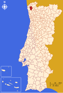
| Country | |
| Region | Norte |
| Intermunic. comm. | Alto Minho |
| District | Viana do Castelo |
| Parishes | 39 |
| Government | |
| • President | Victor Mendes |
| Area | |
| • Total | 320.25 km2 (123.65 sq mi) |
| Population (2011) | |
| • Total | 43,498 |
| • Density | 140/km2 (350/sq mi) |
| Time zone | UTC±00:00 (WET) |
| • Summer (DST) | UTC+01:00 (WEST) |
| Website | http://www.cm-pontedelima.pt |
Ponte de Lima (Portuguese pronunciation: [ˈpõtɨ ðɨ ˈlimɐ] ⓘ) is the oldest vila (chartered town, head of a municipality) in Portugal. It is part of the district of Viana do Castelo. The population in 2011 was 43,498,[1] in an area of 320.25 km2.[2] The town proper has about 2,800 inhabitants.
It is named after the long medieval bridge (ponte) that passes over the Lima river that runs next to the town.
The current Mayor is Victor Mendes, elected by the People's Party (CDS–PP). It is one of the six municipalities in Portugal administered by this party. The municipal holiday is 20 September.
YouTube Encyclopedic
-
1/5Views:2 7041 0989 1062 522104 221
-
Ponte de Lima - The oldest village in Portugal.
-
🇵🇹 Ponte de Lima - Portugal - Walking Tour (4K UHD 60fps)
-
PONTE DE LIMA 🇵🇹 Drone 4K 2021 | Viana do Castelo PORTUGAL
-
Visite Ponte de Lima
-
Ponte de Lima | Viana do Castelo | Portugal
Transcription
General information

Ponte de Lima is located on the southern bank of the Lima, a small river with sources in Spain.
One of the oldest towns in Portugal (founded on 4 March 1125),[3] it was historically significant as a Roman settlement on the road from Braga to Santiago de Compostela and Lugo, and the first place in Portugal getting a municipal charter. Today, it is a significant stop on the Central Portuguese branch of the Camino de Santiago pilgrimage route.
Every second Monday, it holds one of the largest country markets in Portugal. In the second weekend of September, Ponte de Lima hold the Feiras Novas (the new fairs) for three days since 1826, granted by the Royal Provision of king Peter IV of Portugal.
The attractive rural area surrounding the town has the largest concentration of baroque manors in Portugal (Aurora, Bertiandos, Brandara, Calheiros, and Pomarchão are among the best known); Some provide tourism accommodation. Ponte de Lima is also known in the region and all across Portugal for its red Vinho Verde wines and its sarrabulho rice.
Climate
Ponte de Lima has a Mediterranean Climate
| Climate data for Ponte de Lima, 1980-1990 normals, 1981-2021 precipitation, altitude: 18 m (59 ft) | |||||||||||||
|---|---|---|---|---|---|---|---|---|---|---|---|---|---|
| Month | Jan | Feb | Mar | Apr | May | Jun | Jul | Aug | Sep | Oct | Nov | Dec | Year |
| Mean daily maximum °C (°F) | 14.4 (57.9) |
15.3 (59.5) |
17.7 (63.9) |
18.5 (65.3) |
21.1 (70.0) |
25.0 (77.0) |
28.0 (82.4) |
28.5 (83.3) |
27.5 (81.5) |
22.1 (71.8) |
17.7 (63.9) |
15.2 (59.4) |
20.9 (69.7) |
| Daily mean °C (°F) | 9.2 (48.6) |
10.3 (50.5) |
12.1 (53.8) |
13.3 (55.9) |
15.5 (59.9) |
19.2 (66.6) |
21.4 (70.5) |
21.5 (70.7) |
20.6 (69.1) |
16.4 (61.5) |
12.7 (54.9) |
10.3 (50.5) |
15.2 (59.4) |
| Mean daily minimum °C (°F) | 4.0 (39.2) |
5.4 (41.7) |
6.5 (43.7) |
8.1 (46.6) |
10.0 (50.0) |
13.5 (56.3) |
14.9 (58.8) |
14.5 (58.1) |
13.7 (56.7) |
10.6 (51.1) |
7.7 (45.9) |
5.5 (41.9) |
9.5 (49.2) |
| Average precipitation mm (inches) | 170.4 (6.71) |
134.5 (5.30) |
119.3 (4.70) |
122.1 (4.81) |
95.0 (3.74) |
45.7 (1.80) |
24.2 (0.95) |
35.7 (1.41) |
74.9 (2.95) |
156.6 (6.17) |
175.6 (6.91) |
208.9 (8.22) |
1,362.9 (53.67) |
| Source: Portuguese Environment Agency[4][5] | |||||||||||||
Parishes
Administratively, the municipality is divided into 39 civil parishes (freguesias):[6]
- Anais
- Arca e Ponte de Lima
- Arcos
- Arcozelo
- Ardegão, Freixo e Mato
- Bárrio e Cepões
- Beiral do Lima
- Bertiandos
- Boalhosa
- Brandara
- Cabaços e Fojo Lobal
- Cabração e Moreira do Lima
- Calheiros
- Calvelo
- Correlhã
- Estorãos
- Facha
- Feitosa
- Fontão
- Fornelos e Queijada
- Friastelas
- Gandra
- Gemieira
- Gondufe
- Labruja
- Labrujó, Rendufe e Vilar do Monte
- Navió e Vitorino dos Piães
- Poiares
- Refóios do Lima
- Ribeira
- Sá
- Santa Comba
- Santa Cruz do Lima
- Santa Maria de Rebordões
- Seara
- Serdedelo
- Souto de Rebordões
- Vale do Neiva
- Vitorino das Donas
Notable people

- António de Araújo e Azevedo (1754–1817) a statesman, author, amateur botanist and 1st Count of Barca.
- Francisco de São Luís (1766–1845) a Cardinal of the Catholic Church, the eighth Patriarch of Lisbon, 1840 to 1845.
- Miguel Pereira Forjaz (1769–1827) a general, War Secretary in the Peninsular War and Count of Feira
- Francisco de Melo da Gama de Araújo e Azevedo (1773 – 1859) a field marshal of the Portuguese Army and governor of Diu in Portuguese India 1821 to 1840.
- José Norton de Matos (1867–1955) a Portuguese general and politician.
- Fernando Pimenta (born 1989) a sprint canoeist, silver medallist at the 2012 Summer Olympics and bronze medallist at the 2020 Summer Olympics
- Vasco Costa (born 1991) a footballer with over 250 club caps
References
- ^ Instituto Nacional de Estatística
- ^ "Áreas das freguesias, concelhos, distritos e país". Archived from the original on 5 November 2018. Retrieved 5 November 2018.
- ^ Municipality official website
- ^ "Plano de Gestão da Região hidrográfica do Minho e Lima" (PDF). APA. pp. 103, 115, 119. Retrieved 25 June 2021.
- ^ "SNIRH > Dados de Base". snirh.apambiente.pt. Retrieved 25 June 2021.
- ^ Diário da República. "Law nr. 11-A/2013, pages 552 96-98" (pdf) (in Portuguese). Retrieved 29 July 2014.
External links
| National | |
|---|---|
| Geographic | |
This Viana do Castelo location article is a stub. You can help Wikipedia by expanding it. |