
| Salar de Arizaro | |
|---|---|
 A view of the Salar de Arizaro | |
 Salar de Arizaro | |
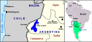 Location of Salar de Arizaro (blue) within northwestern Argentina and South America | |
| Location | Argentina |
| Coordinates | 24°43′22.8″S 67°44′16.8″W / 24.723000°S 67.738000°W |
| Basin countries | Argentina |
| Max. length | 100 km (62 mi)[1] |
| Max. width | 50 km (31 mi)[1] |
| Surface area | 1,600 km2 (618 sq mi) |
| Surface elevation | 3,460 m (11,352 ft) |
| Islands | Cono de Arita |
| Settlements | Tolar Grande |

Salar de Arizaro ("Arizaro" comes from Atacameno haâri "crow", "condor" and ara, aro, "accommodation", "place where something is common".[3]) is a large salt flat of the Andes in north-western Argentina. It is located between the villages of Tolar Grande and Caipe and near Mina La Casualidad,[1] in Los Andes Department, Salta Province.
YouTube Encyclopedic
-
1/1Views:1 943
-
SALAR DE ARIZARO - Tolar Grande a Caipe - SALTA en moto
Transcription
Overview

Located in the central-western area of the Puna de Atacama, it covers an area of 1,600 km2.[4] Per extension, the Salar de Arizaro is the 6th largest salt flat in the World and the 2nd largest in Argentina after the Salinas Grandes.[5][6]
The salar area is mined for metallic and non-metallic resources, as it is rich in salt, marble, iron, copper and onyx.[7]
The nearest salt flats are the ones of Antofalla, Hombre Muerto (both in the north of Catamarca Province), Pocitos (in the east) and the Salinas Grandes of Jujuy and Salta provinces.
The Salar de Arizaro is crossed in the middle by the Salta–Antofagasta railway and the Provincial Route 27[1] (part of the former RN 59). A particular characteristic of it is a conical hill named Cerro Cono (or Cono de Arita),[8] a sandstone-formation.[9]
The Salar de Arizaro is situated in the Lithium Triangle, and the area is being assessed for the extraction of Lithium carbonate by at least two companies: Lithium Chile[10] and LiTHIUM-X[11]
-

Cono de Arita
-

Cono de Arita
See also
Literature
- Gonzalo Monterroso: Touring Argentina - Salta. 1999, ISBN 9879821645
- R. N. Alonso, J. G. Viramonte: Geología y Metalogenia de la Puna. Estudios geol. 43:393-407 (1987)
References
- ^ a b c d (in Spanish) An article about the Salar de Arizaro Archived 2013-01-14 at archive.today
- ^ Salar de Arizaro at NASA Earth Observatory
- ^ Vaisse, Emilio F. (1 January 1895). "Glosario de la lengua atacameña". Anales de la Universidad de Chile (in Spanish): 533. doi:10.5354/anuc.v0i-.20911. ISSN 0717-8883.
- ^ (in Spanish) SEGEMAR (Sistema Geológico Minero Argentino) "Sales" Archived 2014-10-06 at the Wayback Machine. Publicación técnica SEGEMAR – UNSAM Nº 9 – Diciembre 2003 – ISSN 0329-5230 – Dic. 2003.
- ^ (in Spanish) List of greatest Salares at es.wp
- ^ Salar de Arizaro at mindat.org
- ^ Salar de Arizaro Earth Snapshot
- ^ (in Spanish) A picture of the Cerro Cono with a brief description Archived 2014-03-04 at the Wayback Machine
- ^ (in Spanish) Noticiero Salta: ¿El Cono de Arita es natural o un monumento milenario? Archived 2013-02-01 at the Wayback Machine
- ^ "Lithium Chile - Salar de Arizaro".
- ^ "LiTHIUM-X - Arizaro".
External links
- (in Spanish) Salar de Arizaro on Salta Province website
| International | |
|---|---|
| Other | |