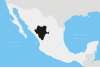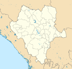

Topia is a city and seat of the municipality of Topia, in the state of Durango, north-western Mexico.[1] As of 2010, the town of Topia had a population of 2,051.[2]
YouTube Encyclopedic
-
1/2Views:3 42212 586
-
Όμορφα τοπία της Γης
-
Topia Dgo. Abril14
Transcription
Geography
Climate
| Climate data for Topia (1951–2010) | |||||||||||||
|---|---|---|---|---|---|---|---|---|---|---|---|---|---|
| Month | Jan | Feb | Mar | Apr | May | Jun | Jul | Aug | Sep | Oct | Nov | Dec | Year |
| Record high °C (°F) | 29.5 (85.1) |
30.5 (86.9) |
37.5 (99.5) |
35.5 (95.9) |
34.5 (94.1) |
38.5 (101.3) |
35.0 (95.0) |
32.0 (89.6) |
38.0 (100.4) |
31.5 (88.7) |
30.5 (86.9) |
29.5 (85.1) |
38.5 (101.3) |
| Mean daily maximum °C (°F) | 18.4 (65.1) |
19.9 (67.8) |
22.0 (71.6) |
25.1 (77.2) |
27.3 (81.1) |
27.8 (82.0) |
24.7 (76.5) |
24.7 (76.5) |
24.7 (76.5) |
24.1 (75.4) |
22.0 (71.6) |
19.7 (67.5) |
23.4 (74.1) |
| Daily mean °C (°F) | 13.0 (55.4) |
13.8 (56.8) |
15.4 (59.7) |
18.2 (64.8) |
20.5 (68.9) |
21.7 (71.1) |
20.0 (68.0) |
20.0 (68.0) |
20.1 (68.2) |
18.8 (65.8) |
16.3 (61.3) |
14.1 (57.4) |
17.7 (63.9) |
| Mean daily minimum °C (°F) | 7.5 (45.5) |
7.7 (45.9) |
8.9 (48.0) |
11.4 (52.5) |
13.7 (56.7) |
15.6 (60.1) |
15.4 (59.7) |
15.4 (59.7) |
15.4 (59.7) |
13.4 (56.1) |
10.5 (50.9) |
8.6 (47.5) |
12.0 (53.6) |
| Record low °C (°F) | −2.0 (28.4) |
0.0 (32.0) |
0.0 (32.0) |
2.0 (35.6) |
6.5 (43.7) |
6.5 (43.7) |
8.0 (46.4) |
4.0 (39.2) |
8.0 (46.4) |
6.0 (42.8) |
0.0 (32.0) |
−2.0 (28.4) |
−2.0 (28.4) |
| Average precipitation mm (inches) | 110.7 (4.36) |
40.3 (1.59) |
26.8 (1.06) |
11.7 (0.46) |
14.8 (0.58) |
106.2 (4.18) |
277.2 (10.91) |
228.0 (8.98) |
160.4 (6.31) |
95.2 (3.75) |
47.7 (1.88) |
104.5 (4.11) |
1,223.5 (48.17) |
| Average precipitation days (≥ 0.1 mm) | 4.9 | 2.5 | 1.7 | 1.4 | 1.8 | 10.4 | 24.0 | 21.6 | 14.1 | 6.2 | 2.7 | 4.8 | 96.1 |
| Source: Servicio Meteorologico Nacional[3][4] | |||||||||||||
References
- ^ Instituto Nacional de Estadística y Geografía. Principales resultados por localidad 2005 (ITER). Retrieved on December 23, 2008
- ^ "Topia". Catálogo de Localidades. Secretaría de Desarrollo Social (SEDESOL). Retrieved 23 April 2014.
- ^ "Estado de Durango-Estacion: Topia". Normales Climatologicas 1951–2010 (in Spanish). Servicio Meteorologico Nacional. Retrieved 1 July 2016.
- ^ "Extreme Temperatures and Precipitation for Topia 1953–1985" (in Spanish). Servicio Meteorológico Nacional. Retrieved 1 July 2016.
This article about a location in the Mexican state of Durango is a stub. You can help Wikipedia by expanding it. |