
Trường Sa
Thị trấn Trường Sa | |
|---|---|
| Trường Sa township | |
 | |
 | |
 Trường Sa | |
| Coordinates: 8°38′41″N 111°55′12″E / 8.64472°N 111.92000°E | |
| Country | |
| Region | South China Sea |
| Province | Khánh Hòa |
| District | Trường Sa |
| Population (2019) | |
| • Total | 31 |
| Time zone | UTC+7 (UTC + 7) |
Trường Sa is a township (thị trấn) and capital of Trường Sa District, Khánh Hòa Province, Vietnam.[1]
The township consists of Spratly Island and nearby islands, reefs and banks.
History
The township was established on April 11, 2007 under the Vietnam Government's Decree 65/2007/NĐ-CP.[2]
Traffic
The town has a regional airport, Truong Sa Airport, with a runway length of 1,200 m that can accommodate small planes to transport people and necessities as well as transport patients to the mainland. The airport management and technical assurance department is in charge of the General Staff Department, Division 370.[3]
The town also has a lock with many piers that can accommodate many boats at the same time.
Islands and atolls belong
Islands
| S. No. | Island name | Vietnamese name | in Atoll | Area (ha) | Image | Note |
|---|---|---|---|---|---|---|
| 1 | Spratly Island | Đảo Trường Sa Lớn | Spratly Island | 36.5 | 
|
Spratly Island and West Reef East Island are the only two islands of Truong Sa township inhabited by civilians. People here make a living by fishing at sea and raising livestock, but some food still has to be imported from the mainland. On the sunken and floating islands, cows relax under the shade of trees, flocks of saltwater ducks search for food on the beach, dogs catch fish with soldiers, lush green vegetable gardens, and flocks of fish swim around the wharf. like at home's pond, square almond trees, maple trees, ancient storm trees fragrant with flowers... All those peaceful images are no different from a picture of a vibrant countryside on the mainland. |
| 2 | West Reef East Island[4] | Đảo Đá Tây A | West London Reef | 11 | 
| |
| 3 | Da Lat Island | Đảo Đá Lát | Ladd Reef | 1.3 | 
|
In early November 2022, Vietnam began accreting and renovating Da Lat Island into an artificial island. |
| 4 | Truong Sa Dong Island | Đảo Trường Sa Đông | Central London Reef | 10 | 
|
Truong Sa Dong Island is a small sand island in Central London Reef |
| 5 | Phan Vinh Island | Đảo Phan Vinh | Pearson Reef | 60 | 
|
Phan Vinh Island is a small sandy island belonging to Pearson Reef. Today, Vietnam has built up a large island with an area 13 times its natural area. In the illustration is the original island (natural). |
| 6 | Nui Le A Island | Đảo Núi Le A | Cornwallis South Reef | 5 | 
|
At the end of October 2022, Vietnam continued to expand this island and planted many coconut trees on it. |
| 7 | Toc Tan A Island | Đảo Tốc Tan A | Alison Reef | 2 | 
|
In early December 2022, Vietnam began conducting dredging and accretion activities on Toc Tan A Island. As of November 2023, Toc Tan A has become an artificial island with an area of about 2 hectares, about 150 m long, about 140 m wide, with a jetty on the south side. |
| 8 | Tien Nu Island | Đảo Tiên Nữ | Tennent Reef | 26 | 
|
Vietnam has built artificial islands located Tennent Reef with the current area of 26 hectares. |
| 9 | Thuyen Chai Island | Đảo Thuyền Chài | Barque Canada Reef | 112 | 
|
Thuyen Chai Island is a newly built artificial island by Vietnam located on Barque Canada Reef. This is also the largest island (both natural and artificial) occupied and controlled by Vietnam. |
| 10 | Amboyna Cay | Đảo An Bang | Amboyna Cay | 1.6 | 
|
Initially, this island was called Cồn cát An Bang by Vietnam. Then changed the calling to Đảo An Bang as today. |
Atolls
| S. No. | Reef name | Vietnamese Name | Image |
|---|---|---|---|
| 1 | Ladd Reef | Đá Lát | 
|
| 2 | West London Reef | Đá Tây | 
|
| 3 | Central London Reef | Đá Giữa | 
|
| 4 | East London Reef | Đá Đông | 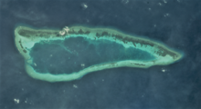
|
| 5 | Pearson Reef | Rạn san hô vòng Pearson | 
|
| 6 | Alison Reef | Đá Tốc Tan | 
|
| 7 | Cornwallis South Reef | Đá Núi Le | 
|
| 8 | Tennent Reef | Đá Tiên Nữ | 
|
| 9 | Barque Canada Reef | Bãi Thuyền Chài | 
|
See also
References
- ^ Ministry of Public Information in Vietnam Archived 2012-08-20 at the Wayback Machine
- ^ "Nghị định 65/2007/NĐ-CP về việc điều chỉnh địa giới hành chính thị xã Cam Ranh và huyện Diên Khánh để thành lập huyện Cam Lâm; điều chỉnh địa giới hành chính để thành lập xã, thị trấn thuộc các huyện: Cam Lâm, Trường Sa và mở rộng phường Cam Nghĩa thuộc thị xã Cam Ranh, tỉnh Khánh Hòa".
- ^ "Chuyện kể trên đường băng Trường Sa".
- ^ https://www.rfa.org/english/news/special/scs-80/
Capital: Nha Trang | ||
| Nha Trang | Ward (19): Lộc Thọ · Ngọc Hiệp · Phước Hải · Phước Hòa · Phước Long · Phước Tân · Phước Tiến · Phương Sài · Phương Sơn · Tân Lập · Vạn Thắng · Vạn Thạnh · Vĩnh Hải · Vĩnh Hòa · Vĩnh Phước · Vĩnh Trường · Vĩnh Nguyên · Vĩnh Thọ · Xương Huân commune (8): Phước Đồng · Vĩnh Phương · Vĩnh Thạnh · Vĩnh Trung · Vĩnh Thái · Vĩnh Hiệp · Vĩnh Ngọc · Vĩnh Lương |  |
| Cam Ranh |
| |
| Ninh Hòa |
| |
| Cam Lâm District | Cam An Bắc · Cam An Nam · Cam Hải Đông · Cam Hải Tây · Cam Hiệp Bắc · Cam Hiệp Nam · Cam Hòa · Cam Phước Tây · Cam Tân · Cam Thành Bắc · Suối Tân · Sơn Tân · Suối Cát | |
| Diên Khánh District |
| |
| Khánh Sơn District |
| |
| Khánh Vĩnh District |
| |
| Trường Sa District |
| |
| Vạn Ninh District |
| |
This article about a location in Khánh Hòa Province, Vietnam is a stub. You can help Wikipedia by expanding it. |