
| Ucayali moist forests (NT0174) | |
|---|---|
 Montane rainforest on the mountain ridge between Region de San Martin and Region de Loreto | |
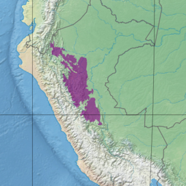 Ecoregion territory (in purple) | |
| Ecology | |
| Realm | Neotropical |
| Biome | tropical and subtropical moist broadleaf forests |
| Bird species | >600 |
| Mammal species | 188 |
| Geography | |
| Countries | Peru |
| Coordinates | 7°45′07″S 75°51′14″W / 7.752°S 75.854°W |
| Geology | Ucayali Basin |
| Rivers | Marañon, Ucayali |
| Climate type | Af: equatorial, fully humid |
The Ucayali moist forests (NT0174) is an ecoregion in the western Amazon rainforest of Peru.
YouTube Encyclopedic
-
1/1Views:865
-
Black-necked Cotinga in the Yasuni
Transcription
Geography
Location
The Ucayali moist forest ecoregion is to the east of the Andes mountains in Peru. It is bounded to the east by the Ucayali River, a major tributary of the Amazon River. To the north it is bounded by the Marañón River.[1]
In the extreme northwest the Ucayali moist forests transition into the Eastern Cordillera Real montane forests. Across the Marañón River valley they transition into the Marañón dry forests, then along most of their western and southern boundary they transition into the Peruvian Yungas. To the east they are separated from the Southwest Amazon moist forests by a belt of Iquitos várzea along the Ucayali River, and to the north they are separated from the Napo moist forests by a belt of Iquitos varzea along the Marañón River.[2]
Terrain
The sub-Andean terrain is generally flat, but is divided by the Cordillera Oriental, highlands that run along the length of the ecoregion. Elevations are 200 to 1,100 metres (660 to 3,610 ft) above sea level. Many rivers and streams flow from the mountains to the west into the upper Amazon basin.[3]
Climate
Annual rainfall is 600–2,500 millimetres (24–98 in).[3] At a sample location at 7°45′S 75°45′W / 7.75°S 75.75°W the Köppen climate classification is "Af": equatorial, fully humid. Mean temperatures range from 24.7 °C (76.5 °F) in July to 26.1 °C (79.0 °F) in November. Yearly total rainfall is about 1,700 millimetres (67 in). Monthly rainfall ranges from 62.4 millimetres (2.46 in) in August to 205.9 millimetres (8.11 in) in March.[4]
Ecology
The ecoregion is in the Neotropical realm, in the tropical and subtropical moist broadleaf forests biome.[5]
Flora
Forests are transitional between wet lowland rainforest to the east and premontane moist forests higher up.[3] The ecoregion has diverse flora, with many species of palm. Tropical hardwood species include mahogany, tropical cedar and kapok.[5]
Fauna
188 species of mammals have been recorded. There are over 600 species of birds. There are also large populations of many species of invertebrates, amphibians and reptiles.[5]
Endangered mammals include white-bellied spider monkey (Ateles belzebuth), Peruvian spider monkey (Ateles chamek), Rio Mayo titi (Callicebus oenanthe) and giant otter (Pteronura brasiliensis). Endangered amphibians include Silverstone's poison frog (Ameerega silverstonei) and Johnson's horned treefrog (Hemiphractus johnsoni).[6]
Status
The World Wildlife Fund gives the ecoregion the status of "Vulnerable".[3] The Cordillera Azul National Park protects part of the ecoregion.[5]
References
- ^ Ucayali moist forests – Myers, WWF Abstract (map).
- ^ WildFinder – WWF.
- ^ a b c d Sears & Schipper.
- ^ Ucayali moist forests – Myers, Climate Data.
- ^ a b c d Ucayali moist forests – Myers, WWF Abstract.
- ^ Ucayali moist forests – Myers, All Endangered.
Bibliography
- Sears, Robin; Schipper, Jan, Eastern South America: Central Peru (NT0174), WWF: World Wildlife Fund, retrieved 2017-04-30
- "Ucayali moist forests", Global Species, Myers Enterprises II, retrieved 2017-04-30
- WildFinder, WWF: World Wildlife Fund, retrieved 2017-04-26