
Vaalwater | |
|---|---|
 R33 in Vaalwater | |
 Vaalwater  Vaalwater | |
| Coordinates: 24°17′S 28°6′E / 24.283°S 28.100°E | |
| Country | South Africa |
| Province | Limpopo |
| District | Waterberg |
| Municipality | Modimolle–Mookgophong |
| Area | |
| • Total | 10.51 km2 (4.06 sq mi) |
| Population (2011)[1] | |
| • Total | 3,964 |
| • Density | 380/km2 (980/sq mi) |
| Racial makeup (2011) | |
| • Black African | 87.4% |
| • Coloured | 0% |
| • Indian | 0.25% |
| • White | 12% |
| First languages (2011) | |
| • Sepedi | 64.3% |
| • Afrikaans | 11.3% |
| • Tsonga | 7,9% |
| Time zone | UTC+2 (SAST) |
| PO box | 8888 |
| Area code | 014 |
Vaalwater is a small town situated on the Mokolo River in the Limpopo province of South Africa.
YouTube Encyclopedic
-
1/1Views:1 533
-
Vaalwater, RSA
Transcription
Geography
Location
The town, unlike other towns in the Limpopo province, is not located on a national road, of which the nearest one is at Nylstroom/Modimolle. It does however lie halfway on a road stretching from Nylstroom/Modimolle to Ellisras/Lephalale (the R33 Route). Nearby towns also include Hermanusdorings, Melkrivier, Palala and Naboomspruit.
Geography

It lies at the southern edge of the rugged Waterberg Massif, which is a biosphere that contains considerable biodiversity, including numerous large mammals (e.g. Giraffe, White Rhino, Blue Wildebeest). Waterberg is the first region in the northern part of South Africa to be named as a Biosphere Reserve by UNESCO. The extensive rock formation was shaped by hundreds of millions of years of riverine erosion to yield diverse bluff and butte landform.[2]
Economy
Tourism
Vaalwater is a popular jumping-off point for travels to the Waterberg Massif and Botswana and is itself becoming a minor destination for tourism. There are a variety of craft, art, and gift shops, as well as cafes and restaurants. Vaalwater is also home to some of the most magnificent game farms and eco-tourism in the country. Many of the game farms host the Big Five, and nature-lovers will find the mountains, bush and wildlife worth the visit.
Services
Vaalwater has a number of commercial services not common for kilometres around, especially on roads leading to Botswana. These include banking, groceries, petrol and diesel, a post office, and doctors.
Name
In 2006, Vaalwater was officially renamed Mabatlane, but reverted to Vaalwater in 2007 after it became evident that the proper renaming procedures had not been followed.[citation needed]
References
- ^ a b c d "Main Place Vaalwater". Census 2011.
- ^ "C.Michael Hogan, Mark L. Cooke and Helen Murray, The Waterberg Biosphere, Lumina Technologies, May 22, 2006". Archived from the original on March 24, 2007. Retrieved June 10, 2010.
External links
Municipalities and communities of Waterberg District Municipality, Limpopo | ||
|---|---|---|
District seat: Nylstroom (Modimolle) | ||
| Thabazimbi | 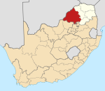 | |
| Lephalale |
| |
| Modimolle–Mookgophong |
| |
| Bela-Bela |
| |
| Mogalakwena |
| |